Garmin Instinct and disappearing waypoint datafields

Hello Everybody

I hope somebody can help me out because I feel like I'm going to lose my mind here.I got myself a Garmin Instinct just a couple of days ago, and things were going great until I began testing out it's navigation function.

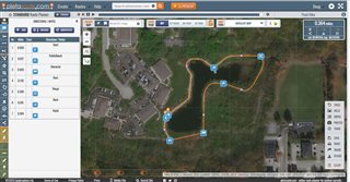
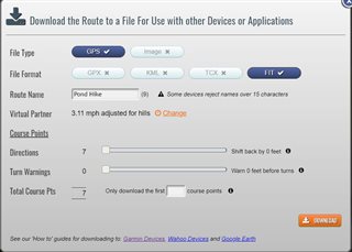
More specifically, the Course Points I add to any course via Garmin Express (which count as Waypoints on the Instinct datafields), disappear from my "Next Waypoint" datafield on the Instinct the moment I get "on route" leaving me with a blank "Next Waypoint" datafield.

I have tested multiple courses, waypoint names and a few navigation settings but I cannot for the love of me figure out how this makes any sense or If I'm doing something wrong.

Attached is a video for reference where you can see the Course point named "ONE" promptly disappearing the instant I get on the GPS course.

  • I believe I sort of figured out what's going on. It seems to be a bug related to the turn-by-turn feature enabled with any course sent directly from the Connect app. By using the website and loading the .fit file manually, you get properly working waypoints on the datafields but no turn-by-turn navigation.
    Gotta admit this is all pretty wonky, is there any way to have both features co-exist and is Garmin planning to fix this?
  • Aight, I've done some trials and correct me if I am wrong:
    • Courses done via the GARMIN CONNECT APP come baked with turn by turn which means no Course Points due some conflict in the Instinct "Next Waypoint" datafield
    • Courses done via the GARMIN CONNECT WEBSITE and sent straight to the watch via cable retain working Course Points due to the lack of turn-by-turn
    Thing is, both of the above need a web connection, what If I want an offline solution with working CoursePoints and/or turn-by-turn? So far I've tried:
    • Garmin Express: Complete and utter garbage, barely functional, has no routing, CoursePoints do show on the datafield but DON'T actually work (you won't navigate through them despite hitting the locations and the Instinct will stay stuck on the first Course point). Crashes the watch from time to time
    • BaseCamp: Feels like a powerful tool but neither route directions nor Via Points seem to translate to Turn-by-turn and Waypoints respectively, once sent to the Instinct. Tried multiple settings but no cigar, so either I'm missing something or is it simply not an option?
    What do you use for offline course plotting which includes working CoursePoint navigation?
    Please help me out, I feel like I'm running in circles.
  • Use Plotaroute.com.

    Create a route and add navigation info where you like.  Save a .fit file then copy into the \Garmin\newfiles folder of your device while connected via USB.  See screenshots below.  I provided another link where I learned the technique.  

    Further reading:

    https://forums.garmin.com/outdoor-recreation/outdoor-recreation/f/fenix-6-series/192222/next-waypoint-and-distance-to-next-showing-distance-to-next-turn/935771#935771

  • Oh wow Thank you!
    I have no way to do an in-depth testing right now, but Plotaroute actually seems like it's working properly, at least for waypoints. Tomorrow I'll check if it does the same with Turn By Turn!


    Only downside is that it's a website and thus purely online. Are there any purely offline options?

  • Not that I've found.  I'm really interested in getting the Instinct to work as closely to my GPSMap 64.  Pretty similar, but just different enough to be slightly annoying regarding track/waypoint navigation.  I'll take the good with the bad, however.  There are a few quirks, but it's amazing what is packed into this thing.

  • Alright, I've had the chance to test Plotaroute out and it's definitely working exactly the way I originally expected Explore and Connect to do when it comes to waypoints and navigation. Really kinda impressive how a 3rd party website can manage it while 3 different native applications from the actual manufacturers can't.

    This watch is such a beautiful thing, really wish the app ecosystem was on par.

  • Glad it's working for you.  I use BaseCamp and Plotaroute as my mainline workflow tools to generate hiking/walking and in some cases bike routes since the Edge devices behave similarly and have a similar file structure to the Instinct.  I use BaseCamp also for my Track/Waypoint organizational/storage tool for my Instinct, GPSMap 64, and Edge 530.  BaseCamp is a great (and mature) product.  Its only drawback is it only works on PC/MAC platforms.

    I have abandoned the Explore environment all together.  I spent way too much time trying to get it to work with the watch as a route/waypoint development tool.  The phone app does have some uses via it's offline functionality (no cell coverage) to create routing in a pinch.