
Hi there,
being a long time user of Garmin Vista HCx and etrex 30, I recently upgraded myself to GPSMAP 66 and edge 1030. My "workflow" used to be .gpx files stored locally on my computer and transferring these using USB mass storage connection to the etrex. Whilst trying the Garmin Connect platform, I noticed issues in the handling of elevation data that is contained in tracks. I searched the forum and googled, but did not find references. Has somebody come across the following issue, or is this a known issue?
.gpx Tracks imported into Garmin Connect (Training - Course - Import, Elev. Corrections disabled) do show a total elevation gain and loss that differs from the .gpx file, but are still in a plausible range. When downloaded as .fit or sent to the device, total elevation gain is way off.
I tried to narrow the issue down by performing the following steps:
1 .gpx file of an mountainbike tour recorded on my etrex 30. Based on longtime usage and comparison of the elevation data with Vista HCx, Polar V800 and tour books, I do have confidence in the readings
file opened in QLandkarteGT, a mapping software I use for years: 88.08 km, 5347 data points, total elevation gain 2116m, total elevation loss 2104m
2. imported as activity into Garmin Connect (Training - Course - Import, Elev. Corrections disabled)
Stats show 88.08 km, total elevation gain 2068m, total elevation loss 2056m
(note: when Elev. Corrections enabled, total elevation gain 2431m, total elevation loss 2431m)
3. when downloaded from the activity page (Export original, Export to TCX, Export to GPX) all tracks show the distance, No. of datapoints and total elevation gain / loss of the original file
4. save as course, type: Mountain Biking
stats show the total elevation gain / loss we saw before during the import, depending whether Elev. Corrections is enabled or not.
5. download the course
Training - Course - Download (GPX) gives a .gpx file without elevation information. Should be addressed separately by Garmin, but is not the key issue here
Training - Course - Download (FIT) gives a .fit file, that I converted using gpsbabel 1.5.4. The resulting .gpx shows
88.08 km, 4003 data points, total elevation gain 6213m, total elevation loss 6200m
which is obviously way off.
6. send course to edge 1030
course overview shows a total elevation gain / loss of approx. 5300m, the .fit file copied from the device, converted using gpsbabel shows
88.08 km, 4003 data points, total elevation gain 6213m, total elevation loss 6200m
which is pretty much identical of the file received in the previous step
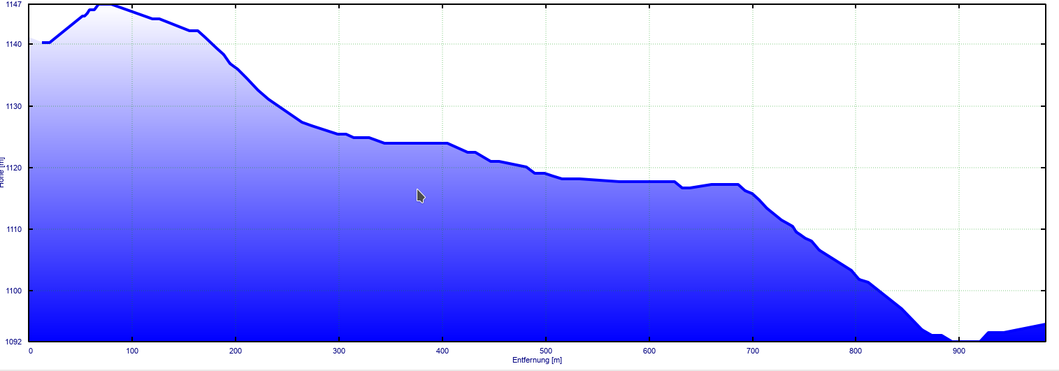
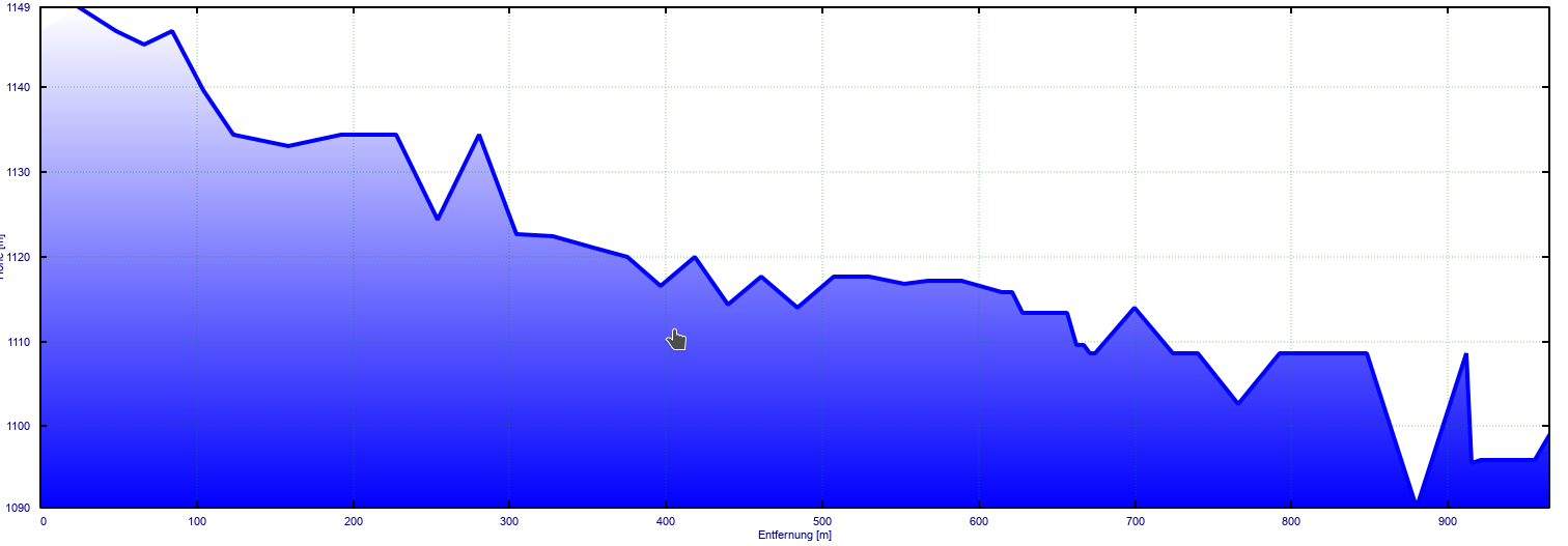
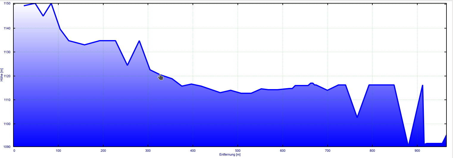
Interestingly, the shape of both track from step 5 and 6 seems to remain intact, eg. elevation of individual points is still plausible.However: when zooming into the elevation profile, the reason for the way off indications becomes visual: the original .gpx shows a very smooth profile, whilst the data received from Garmin Connect adds a significant "jitter". This jitter simply adds up tot a total, that is way off.
I added screenshots of elevation profile of the original track, downloaded .fit file without and with enabled elevation correction. The segment from the track is the same (km 60), I tried to give the same scaling of the y axis.
Would appreciate feedback or to provide further information of needed.
Regards,
Robert ciq.forums.garmin.com/.../1439164.png ciq.forums.garmin.com/.../1439165.png ciq.forums.garmin.com/.../1439166.png
