
When I try to place points on a bicycle route, the computer always redirects me towards the nearest road.
On the picture you see how I place the point on the road indicated by the dashed line. But the software does not detect this and makes the pink route using the highway.
When I place the waypoints very close together, the software sometimes acknowledges this road, but it does not always work.
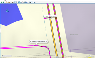
Is there a setting or a shortcut I can use that allows a better way to detect those routes?
