This discussion has been locked.
You can no longer post new replies to this discussion. If you have a question you can start a new discussion

BaseCamp doesn't calculate any routes

Unfortunately all the threads I've read don't fix the problem I've got with BaseCamp.

  • BC Version 4.8.7
  • Mac OS Catalina 10.15.2
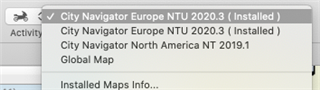
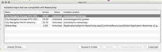
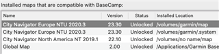
  • Map: City Navigator Europe NTU 2020.3, Version 23.30, installed on the Mac
  • GPS: Zümo 390LM

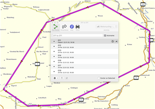
I'm trying to plan a route, but the calculation window only appears so quick, that I even can't read any status message in the window.

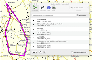
The route calculation seems not to work, only straight lines between waypoints or route points as a result.

Any ideas on this issue?

Many Thanks!

  • Are your route options set to "direct,"

    Rather than "motorcycling?"

  • Tried different route options, from "curvy" to "direct", no difference.

    Could it be, that the map is not routable? I just clicked on "calculate" on an old route and it left the route with only straight lines too and I can't change it back anymore...

    Is there a way to check the route whether it's a routable one? It's the original route on the device, updated to the latest version of course.

  • Looking at your screenshot it appears to be the CN map, and that is certainly routeable.  You do have that map selected I assume and it's not some other map that is showing/selected?

  • Same issue on my Mac with the same versions Thumbsdown

  • Very weird, if your device is connected and you choose the map on the device in BC does it then work?

  • Very weird indeed!

    I just made some research and found the following:

    • GPS connected to the Mac
    • Map "Europe" appears twice (see screen shot above)
    • The map on top is a complete map of Europe, but only about the northern half is detailed, the southern half is similar to the Global Map in terms of detail.
    • The second map "Europe" is the opposite version: south detailed, north similar to the Global Map

    And now the really strange realization:

    • Routing kind of works in the southern part (not the detailed) of the upper map, but there are lot of streets missing of course
    • Routing kind of works in the northern part (not the detailed) of the second map, again, streets missing, so routing not useful
    • in the detailed parts of both maps, where all streets are available, the routing doesn't work, resp. only creates straight lines between waypoints, also if there once was a correct route, this is going to be "straightened" when pressing the calculate button :-(
    • This is infact weird...

    Thanks so far for your effort in trying to help to sort this out! 

    Screenshot 1: Routing in the detailed part of the map: (straight lines)

    Screenshot 2: Routing in the less detailed part of the map: (same area, the other map, not useful)

  • just in case this might be a helpful information:

  • Some more info:

    • installed the map "Europe" locally
    • unplugged the gps
    • the whole of Europe is now detailed on the locally installed map
    • roting doesn't work at all => only straight lines (in northern and southern regions)

  • OK, well first you shouldn't be seeing the EU map split in two as you describe.  The EU map is split, but only when installed to your device as there is a 4Gb limit with the FAT32 format, and as the map of the EU now exceeds that it's split.  In BaseCamp it should appear as one map.  You appear to be using maps from your device, which is why you're having the issue.  Use Garmin Express to install the full EU map to your Mac, then when you select it the routing should work perfectly.

  • Thank you, already tried this, but it still doesn't calculate routes (please see my latest post above)