This discussion has been locked.
You can no longer post new replies to this discussion. If you have a question you can start a new discussion

Potential Solution to Barometric Altimeter Problem for VA3

Former Member
Former Member
I think I may have found a potential (temporary) solution to the problematic altimeter that we all face (Temporary because software updates should come from Garmin). Please try this out and feedback in this thread if it works for you. If we have enough sample size from everyone that tries out this method, it should give enough reasons for Garmin to do a minor software update to fix this long overdue problem / "bug".

I have tried this method several times and it seems that the elevation data that is reported out by my VA3 is comparable to what I'd get if "Elevation Correction is Enabled" in web version of Garmin Connect.

Follow the steps closely:
1. Under Settings --> Activities & Apps --> Run --> Run Settings --> GPS, I set them to "GPS + GLONASS".
2. Under Settings --> Activities & Apps --> Run --> Run Settings --> Data Screens --> Screen 1 --> Edit Data Fields --> I put "Elevation" at the 2nd data field.
3. Start a running activity after you obtain "Green GPS" signal. (But you don't have to run!)
4. Take note on your elevation value. If the value does not make any sense, wait for a few minutes until the value shown is somewhat the correct value (depends on where you are!)
5. After waiting for few minutes, or after you see the value is OK, stop the activity and discard it.
6. Turn off the watch.
7. Turn on the watch.
8. Start a running activity, after getting the "Green GPS" signal.
9. Run! (If you can do a few loops of a known course, that you would be best. Later in GC we should be able to see several cycles of the same elevation profile repeating)
10. Stop and save your activity.
11. Sync with GC
12. Check the activity in GC. Hopefully, your elevation profile is now correct.

My versions are as follows:
SW Ver 6.10
GPS Ver 2.50
TSC Ver 2.10
Sensor Ver 6.00
WHR Ver 20.03.31
Connect IQ Ver 3.0.9

P.S.: To be honest, I personally do not think the barometric altimeter hole under the watch will have any effect to the elevation readings. The reason is because your skin will never ever ever ever be able to create a hermetic seal around the hole (unless if your skin is made from rubber, and it covers the hole with precise dimensions!). Of course, it "appears" that your skin blocks the hole, but that is not how atmospheric pressure works....

P.S.S: Also, because my steps above helped me to achieve a more "believe-able" readings from the built-in altimeter, I highly suspect it is a software related issue (which is a good news for us!). I do not recall having this issue when I first got the watch more than a year ago.....

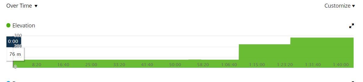
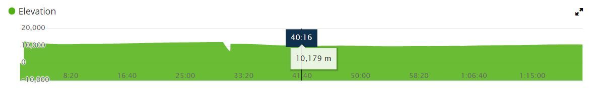
Please try and report back your findings here. Thanks! ciq.forums.garmin.com/.../1471404.jpg ciq.forums.garmin.com/.../1471405.jpg
  • Nice that this seems to work!
    But I think the reason for it, is something else:
    From my findings, the elevation is (mostly) fine after about ~15 minutes. Which leads me to the conclusion, the watch has to acclimate somehow.
    Normally you come from the inside, where a different temperature warm up (or cool down) the device itself.
    Now there is a gap, if you are getting outside. Then you start to warm up yourself doing an activity and, off course the inside of the watch!
    Your skin might not completely cover the sensor hole, but your sweat does.
    The GPS often shows green, but you can see from the pace and sometimes also from crazy waypoints, that it is only "orange" (which is not shown in the regular garmin app).

    Then there is the "automatic calibration" which takes the "orange"-signal from the start and all the external influences.
    What you are doing is to give the watch the time to acclimate and probably persisting a better calibration value by restarting it.

    You cannot overcome the physical problems. But I´m with you, that this should be possible to be straighten or compensate via software.
    It often is reliable, that the starting point is 40 meter to high and 3km later it seems to be good enough.
  • I think you're right but it's weird that to many the problems only appeared after some months...My barometer was fine for about 2 months. But from my current experience I think the temperature difference may actually be the problem.
  • I didn't test the above method, but I read that you need to wait about 30 sec after the watch locked the GPS signal and before you start running. Here you can find how to calibrate the barometric altimeter.
    With this, my 10 meter inaccuracy went down to 2 meters (which is acceptable for me).


    That doesn't work...in this run I was 5min waiting for the race to start so it had engoug time to calibrate. After 15min the elevation went crazy.

    https://connect.garmin.com/modern/activity/3533698537?share_unique_id=2
  • For me, only one works - clean sensor with water jet. Then I get perfect curve exactly for a single activity. Second one and all after will be lowering ca. 10m per Minute... Honestly, I do not understand how it could be. It does not matter if I have GPS only or a combination.
  • Former Member
    0 Former Member over 6 years ago
    That doesn't work...in this run I was 5min waiting for the race to start so it had engoug time to calibrate. After 15min the elevation went crazy.
    ...


    Race? If there are a lot of devices (noise) around you, the GPS accuracy, and thus the calibration of altimeter also can be effected and therefore, bad. Try it once when you are running alone.
  • Race? If there are a lot of devices (noise) around you, the GPS accuracy, and thus the calibration of altimeter also can be effected and therefore, bad. ...


    Ahmm. You know that a GPS receiver is only an receiver? And that does not matter if you have 10 or 10 million identical receivers nearby. Furthermore, BL and ANT + are multi-channel and were developed for such conditions if you mean foreign external sensors.
  • Race? If there are a lot of devices (noise) around you, the GPS accuracy, and thus the calibration of altimeter also can be effected and therefore, bad.

    :eek: How in the world should that work?
    The way how GPS / GLONASS / Galileo works, cannot be affected by receiver-devices in any way. It´s a one way satellite signal!
    If I install a solar system, it won´t get colder on your side ;)

    What will have an affect, are the buildings in the inner city of Lissabon.

    *global_local was faster on that

    I´ve made the same experience with the elevation and really tested a lot! And I also wrote down my results compared to the temperature, weather and so on. Starting and ending always at the exact same spot (next to fields, without buildings or trees) and I waited 1-2 minutes before starting.
    The results are all screwed. Each time. At the beginning I thought it would have been better. But it doesn´t. And what seemed to be reliable, started to differ more and more again.
    In my opinion, there is not way to fix this behaviour. It can be reduced and optimized, but never ever solved!
  • Former Member
    0 Former Member over 6 years ago
    Sounds odd or not, my experience is that in big mass the watch's signal is jumping from A to B. Theory and practice differs.
    Anyway, waiting 30 sec before ai start the run helped me to. have a much better elevation record.
  • Former Member
    0 Former Member over 5 years ago

    My brand new VA3 does not show temperature or pressure on any app designed for that purpose (myABC, Temps, and so on). Running FW 7.2 (GPS is 2.5). Could it be a setup mistake from my side?

  • Yo solo lo soluciones restaurando el dispositivo.

    I only solve it by restoring the device.