This discussion has been locked.
You can no longer post new replies to this discussion. If you have a question you can start a new discussion

Elevation when running less accurate than when walking

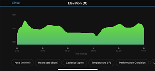
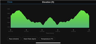
I find when running the elevation data is good initially but then seems to lose accuracy.

See the run below. It is a 40 minute run when I run out for 20 minutes and turn and run back on exactly the same route. The first 20 minutes actually looks pretty good - but as you can see when I return the profile looks totally different and I actually end at a higher elevation than when I started - even though start and finish points are the same.

If I walk this or other similar routes the accuracy looks very good. Any ideas why walking elevation accuracy seems to be better than running?

  • A potential explanation: Wind.

    When you run against gusts of wind, there are moments of increased (or decreased - depending on wind direction) pressure on the barometric sensor, which the watch interprets as decrease/increase of altitude. This is why altitude measurement seems to behave differently on the way back. During walking the barometer port might be less exposed to wind, so the same phenomenon is not so obvious.

    This is just a hypothesis...

  • Thanks for the suggestion.

    The run is actually pretty sheltered from the wind - so it is probably not that I think.

  • Here is a walk in same area. Different route but same principal. Started and walked for 30 minutes and turned and walked back. Here you can see the altitude profile looks like a mirror image from the mid-point - so I think is tracking altitude pretty well.

  • Hello.

    Walking elevation accuracy is often better than running because during activities the FR645 does periodic altitude calibration from GPS. For this calibration, it needs GPS triangulation. The faster you move the more difficult is the triangulation.

    Unfortunately, it seems the FR645 can't calibrate elevation at same time as saving elevation data. Therefore there are datas lost.

    A possible workaround is to manually calibrate the altimeter. When the FR645 is in manual calibration mode, the periodic elevation calibration seems to be off.

    The only inconvenience is, even if the manual calibration mode is active, the FR645 does an elevation calibration by GPS every time at activity start. If this calibration is not accurate (bad GPS triangulation), it tries again later to calibrate elevation and you could have elevation datas lost. If this calibration is OK, the altitude profile of your activity would be OK.