

Can we please, please, PLEASE have the option to record ALL activities with elevation correction?
I live in a very flat area, where Garmin's claimed altimeter accuracy would encompass a good proportion of the county! The elevation plots of my runs bear no resemblance to the terrain I run on.
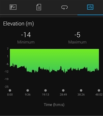
We have thunderstorms forecast today, but I don't need those to get wet. Apparently, the whole of this morning's run was below sea level!
Since it's only really measuring air pressure, which varies, do I need to calibrate before every run to ensure accuracy?
Atmospheric pressure regularly varies by 20 mbar. That equates to around 170 m of elevation. The nighest point in our county is 146 m, so it's plain to see why the altimeter tracks elevation so imprecisely around here.
Corrected elevation gets it right, but I have to manually set it after every run.
So, it seems my options are to calibrate before every run, or enable correction after. Why can I not just choose to use corrected elevation for EVERYTHING? Come on Garmin, you offer premium products. Back them up with premium software solutions and customer service.
