This discussion has been locked.
You can no longer post new replies to this discussion. If you have a question you can start a new discussion

Plotted route does not display additional roads

I've had this issue for some time now, there have been various firmware updates and I have reset my 1030 but I cannot resolve this issue, which unfortunately isn't too easy to explain.

I create a route usually using rRde with GPS (ridewithgps.com) which I can import via the ride with GPS widget installed on my device without issue.

The issue is when I am riding the display will show the road/route I am cycling on but not any junctions or side roads, this causes many issues as I could be approaching a right hand turn (on the screen), but there are 2 right hand turns ahead on the road, because the display isn't showing any roads other than the plotted route sometimes I can miss the correct turn and then have to turnaround and take the next turn if that makes sense.

There must be a setting where I can actually see all roads and my plotted route so I can ensure I take the correct turn?

Any ideas?

  • I've got no idea why I see previous routes, but this isn't uncommon - if I load a route and look at the preview it seems to be a mashup of previous routes???

    The photo was just an example (I went out for a walk to demonstrate the issue).

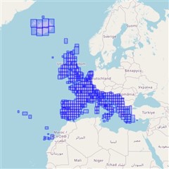
  • The UK is on the South West Map. On an EU device both maps should be installed by default. You shouldn't have to do anything special. When you updated the f/w and maps it should have installed both maps.

    If you go into the navigation settings for your activity. Is the South West Map is listed?

  • You can use the following to see the map coverage:

    www.javawa.nl/jdm_en.html

    "I've got no idea why I see previous routes, but this isn't uncommon - if I load a route and look at the preview it seems to be a mashup of previous routes???"

    The picture isn't of a preview.

    Showing a mashup of other routes would make this feature useless.

  • SW Map Coverage courtesy of Image Info

  • The image you have shared has the road you are on at the top of the screen which suggests that the SW map is installed as that detail of information is unlikely to be on the base map. It looks to me like the Edge is having a difficultly rendering the map. 

    The line you are seeing is probably the track plot of what you are currently recording (ie where you've been since you started the timer) not a route. Maybe there's some corruption in a course or activity on you device that's screwing things up & slowing it down

    As a suggestion. End the current activity. connect your edge to your computer delete/move all courses & activities from the edge. Disconnect the edge from the computer, go outside, power it on, get a gps fix & check the map screen to see if you position is displayed on the map, with the map detail displayed

  • OK, so I listed the maps I had installed above in the post... I didn't have the Garmin Cycle Map EU, South West , 2020.10 Map, I reconnected my 1030 to connect and selected to download the map updates again and now it is listed and enabled and voila I have the map underlay.

    Thanks for your help on this one, it's been infuriating me for nearly a year!!