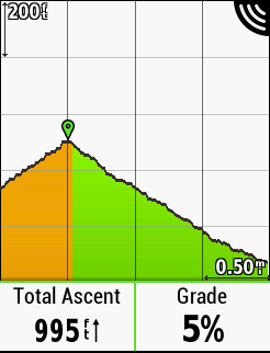
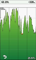
Garmin fixed this on the new 830. No idea why it could not be acknowledged or fixed on the 1030 after all this time. Finally, it accurately shows my position with the pin. It is also on the 25% line. Don…
Is turning TBT off a real solution? This supposed to be cycling navigation. So I'd like to see my route as well as the point on the elevation...
Best regards,
Jarek
Garmin fixed this on the new 830. No idea why it could not be acknowledged or fixed on the 1030 after all this time. Finally, it accurately shows my position with the pin. It is also on the 25% line. Don't think the 1030 will ever get this.
I have the same problem. it's very annoying.
Has anyone noticed that if you load a course FIT file downloaded from RidewithGPS onto the Edge1030 the course elevation profile in the course summary reads 400m low?
I've checked this across a number of courses with the example screen capture having negative altitude for the entire course. It was in Belgium, but I don't think I need a snorkel for any of the ride. GPX/TCX files & the RideWithGPS website all have the correct altitude it seems to be just FIT files that have the issue
Here's a link to the FIT file if anyone would like to check it Belgium Course FIT File
I believe the issue is with the FIT file not the Garmin & have an open support ticket with RideWithGPS. I'll update when I get a response
Is RideWithGPS generating the fit file, if so the problem is with their data. Every single data point is below see level.
It looks like their FIT file generation process has a serious bug.
Here are the first few data points from the course file
distance | 0 | m | altitude | -269 | m |
distance | 2.63 | m | altitude | -269.2 | m |
distance | 62.77 | m | altitude | -271.8 | m |
distance | 106.9 | m | altitude | -271.8 | m |
distance | 134.04 | m | altitude | -271.2 | m |
distance | 153.19 | m | altitude | -270.8 | m |
distance | 168.42 | m | altitude | -270.2 | m |
distance | 185.75 | m | altitude | -269.4 | m |
distance | 203.09 | m | altitude | -268.6 | m |
distance | 228.41 | m | altitude | -267.4 | m |
distance | 236.28 | m | altitude | -267 | m |
distance | 250.09 | m | altitude | -266.8 | m |
distance | 258.55 | m | altitude | -266.8 | m |
distance | 273.12 | m | altitude | -266.4 | m |
distance | 283.38 | m | altitude | -266 | m |
distance | 290.94 | m | altitude | -265.8 | m |
distance | 303.21 | m | altitude | -265.6 | m |
distance | 313.83 | m | altitude | -265.6 | m |
distance | 335.43 | m | altitude | -266.2 | m |
distance | 352.19 | m | altitude | -265.8 | m |
distance | 382.52 | m | altitude | -266 | m |
distance | 395.87 | m | altitude | -265.8 | m |
distance | 411.34 | m | altitude | -265.2 | m |
distance | 428.03 | m | altitude | -264.6 | m |
distance | 444.17 | m | altitude | -263.8 | m |
distance | 471.67 | m | altitude | -262.2 | m |
distance | 606.57 | m | altitude | -258.4 | m |
distance | 634.64 | m | altitude | -257.8 | m |
distance | 651.57 | m | altitude | -257.6 | m |
distance | 879.66 | m | altitude | -249.8 | m |
distance | 1118.66 | m | altitude | -245 | m |
distance | 1169.01 | m | altitude | -244.2 | m |
distance | 1183.43 | m | altitude | -244 | m |
distance | 1198.99 | m | altitude | -244 | m |
distance | 1266.41 | m | altitude | -243 | m |
distance | 1302.94 | m | altitude | -242 | m |
That's correct I downloaded the FIT files from RwGPS and copied them to the Edge newfiles folder. I had 20 courses for my holiday and all had profiles that were 400m lower than what they should be.
I also have the RwGPS CIQ APP & tried it that way too with the same results
This definitely looks like a bug in their (RWGPS) FIT file generation.
The values in the file you posted ranged from -331 meters to -131.6 meters.
That's what I thought too. I imported the FIT file into Golden Cheetah & could see the negative altitudes.
I tried both copying the downloaded course FIT files to the newfiles folder & also using the RwGPS CIQ App to import the files with the same results. If I load the GPX Track & TCX Course files of the same courses the correct altitude profile is displayed
I would normally use the GPX Exporter App to convert & load the GPX track from my phone when I don't have access to a computer, however with the GCM issues surrounding http local host access restrictions with GCM 4.20 it limits how I can get courses on to my device when I don't have a computer to hand & have to use the RwGPS App
I'm still awaiting an update from RwGPS over my support ticket. Hopefully they'll get to the bottom of it quickly
I also passed this on to a contact at RWGPS and they said they were aware of the issue and were looking into it.