This discussion has been locked.
You can no longer post new replies to this discussion. If you have a question you can start a new discussion

2018.10 map different visual style, thinner elements

Hello everyone,

I just updated the maps to the latest version on one of my units and I'm noticing a revised appearance despite the map settings being configured identically on both devices. I was wondering if this is some bug or if everyone else who updated is noticing the change also.

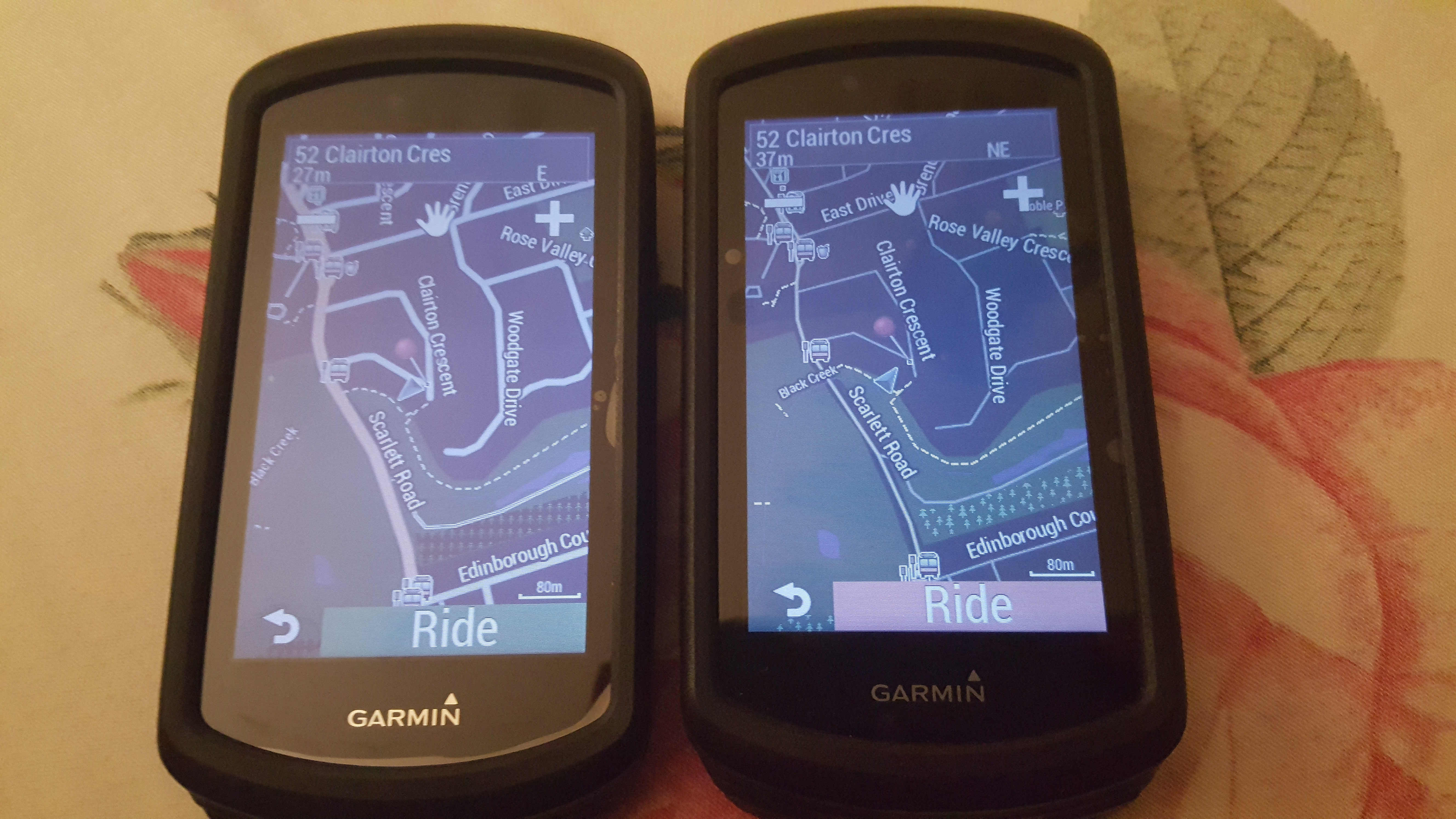
For reference, I'm attaching a jpeg image which will clarify the situation. I personally prefer the old style with thicker roadways. Old map is on the left, new one on the right. ciq.forums.garmin.com/.../1340119.jpg
  • Hi Roman,

    The routing works alright in road cycling mode, it tells you to make a u-turn to get back on course if you miss a turn. It fails when you use automobile routing mode which is supposed to route you on main roads and recalculate intelligently to the next way-point or final destination without u-turns. I find automobile routing preferable on long rides in unknown areas. An example of it's usefulness is when the road you are travelling on is closed for road works, heavily congested or poorly surfaced. In these scenarios instead of perpetually insisting on u-turns and sending you back to the undesirable road, you can bypass the problem and continue on a new route to the final destination (it works like a car GPS which is more useful).

    Did you test this mode, or are you using some other routing option, also are your maps the North American 2018.10?
  • Former Member
    0 Former Member over 6 years ago
    Adding a map to your garmin cannot brick the garmin.
    What i would do.... copy your partners maps to a computer. Rename gmapdem.img to something else (say 2017gmapdem.img)
    Do the same with gmapprom.img and gmapgc.img

    Now put all 3 files on to your 1030 in the garmin folder.
    Create a new activity profile and enable the 2017 maps instead of 2018.

    As an aside, I renamed my 2017 maps when I first used my 1030 just in case I made a mistake. When I updated, I still had my 2017 maps as well as the 2018 ones.
  • As an aside, I renamed my 2017 maps when I first used my 1030 just in case I made a mistake. When I updated, I still had my 2017 maps as well as the 2018 ones.


    Excellent tip!

  • Adding a map to your garmin cannot brick the garmin.
    What i would do.... copy your partners maps to a computer. Rename gmapdem.img to something else (say 2017gmapdem.img)
    Do the same with gmapprom.img and gmapgc.img

    Now put all 3 files on to your 1030 in the garmin folder.
    Create a new activity profile and enable the 2017 maps instead of 2018.

    As an aside, I renamed my 2017 maps when I first used my 1030 just in case I made a mistake. When I updated, I still had my 2017 maps as well as the 2018 ones.


    Thanks, I'll give this a try to revert to my old maps. Garmin insists my routing issue is fixed with 5.0 but it is clearly NOT and no followup was provided to my other thread.

    EDIT:

    Garmin followed up and will take another attempt at fixing the issue.

    I have successfully downgraded the maps by borrowing the files from my riding partner. Instead of placing them on the SD card, I replaced the new maps on the internal storage so the map file structure matches his unit. All unlock and image (gma, unl and img associated with the maps, by date and name) files were deleted. The maps reactivated and work properly with Garmin express now showing an option to update to 2018.10.

    I will now always have backups, prior to any update.
  • Former Member
    0 Former Member over 6 years ago
    would be super nice to get the fat follow line back again!
  • Former Member
    0 Former Member over 6 years ago
    To be fair to Garmin, how you like to see the maps may not necessarily be how I like mine to appear.
    There are tools out there to help you change the map to your own tastes eg https://www.pinns.co.uk/osm/typwiz5.html
    I do prefer the 2017 garmin map over the 2018 but the 2018 has popularity routing so I have each enabled under different profiles.
    I also have another OSM map which has been heavily modified using TYPWiz for greater contrast which I tend to use when heading into forested regions
  • To be fair to Garmin, how you like to see the maps may not necessarily be how I like mine to appear.
    There are tools out there to help you change the map to your own tastes eg https://www.pinns.co.uk/osm/typwiz5.html
    I do prefer the 2017 garmin map over the 2018 but the 2018 has popularity routing so I have each enabled under different profiles.
    I also have another OSM map which has been heavily modified using TYPWiz for greater contrast which I tend to use when heading into forested regions


    Yes definitely, these matters are very subjective. I just feel that graphical consistency from one map release to the next reflects a certain professionalism. My point is that this change wasn't necessary and such changes often cause usability issues if they are not thought out perfectly.

    Thank You for the typ editor link. That is very usefull and I'll definitely try it out sometime.
  • We are still researching the map issues with automotive mode. I did hear back from the mapping team that the thinner style of road is by design. I have reported that this is a concern for some users add will continue to add your feedback. Apologies for the confusion.
  • Thank You for replying Shawn. I look forward to hearing more details about the automobile routing mode. Automobile mode is very useful for navigating when cycling long distance, and not following a course. The recalculation of this mode was superior because it's not as rigid and does not tell you to make u-turns if you stray off course.
  • Former Member
    0 Former Member over 6 years ago
    To my eye, they look better. They're less "clunky".