Altimeter broken or is this normal variation for this watch?

This is a screenshot of the altimeter after a run with the FR955. The insert is the altimeter from a Fenix 5 Plus that I also wore during the run. The run was in the time period marked by the orange lines.

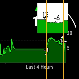
I had been on 10 meters altitude for a a few hours, went downstairs to -2 to run, and went back to 10 meters. The Fenix 5 Plus shows this clearly. Why is the FR955's altimeter so much off? It has never been as good as the Fenix 5 Plus (and 6), but it's been consistently wrong during outdoor activities from this location since September last year, which I attributed to unstable autumn weather. But now I have compared the two a few times and this shows that the FR955 is always varying too far much. This elevation plot from Runalyze shows the pattern more clearly. 

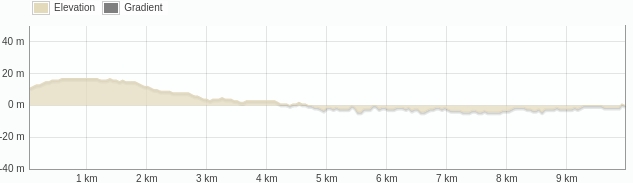
I am 90% convinced it is software, because all other runs that start at altitudes above sea level and do not start shortly after descending stairs, are OK. DEM calibration to an altitude of -2 meters also does not work anymore, it will always calibrate to +2 meters or higher. I don't mind a small offset of a few meters, but the 'fake hill' in the elevation plot is not right and it annoys me. 

I have never swum with the watch or immersed it in water (except for trying to clean the sensor as per Garmins instructions), usually take it off before using hot air hand-dryers (or dry my hands on my socks). I do not always take it off while showering and run in the rain with it, but that should not damage the baro sensor it I think. 

What do you think? Is this more likely to be software or could it still be a sensor issue? 

===

Edit: I compared with similar runs in this location, from other devices. ALL do a better job than the FR955. Fenix 2, 3, 5Plus, 6X, 7, Epix (gen 1) did it right. The Forerunner 935 sometimes also showed this 'fake hill" but not every run and not as pronouced.

  • If I could get used to not having direct USB access to my data in the device and to AMOLED display, I might like the Suunto Vertical 2.
    But their privacy policy mentions: "The Services are provided to you by Suunto Oy and its following affiliates i.e. other companies belonging to the same group of companies owned by Dongguan Liesheng Electronic Co., Ltd..". Where exactly does the data go? GDPR, sure, OK, but another thing is: without the app and access to some backend that stores my data somewhere, how useful is my watch in the long run? Do I get anything I can use if I do a data takeout?

    I even bough a used Polar Grit X and Suunto 5 to see what the software support looked like, if I could use them without apps, and what data (if any) I could get from them. It was an appalling step back. Loads of DIY programming needed and much less rich data.

    What Garmin logs in FIT files is awesome. And I like having FIT files going back years and years that I can all use in whatever way I want. Garmin is still the only brand that has devices that you can use offline for years without ever connecting them to any app or webservice (it may take 15 mins to download ephemeris data but it still just works!)

    Heck, I'm stuck with Garmin, and with this particular model especially. Shame about the failing altimeter, but I still have a Suunto Core somewhere ;-) 

  • I absolutely agree with you when it comes to file access. I am having a look at Coros right now and they seem to have the same problem with not exposing fit files via usb Disappointed. Which is a bummer because feature wise their nomad/apex4 looks great.

  • This long-time Runalyze user is a complete fool, needs new glasses, or both. Two mouseclicks and it's fixed. Never noticed it until I started obsessing over the nonexistent Dutch mountains that kept popping up in my run activities. 
    They could add: "Elevation data from some Forerunner 955's can be rather inaccurate as well.." ;-)

    I'll shut up about it now!