This discussion has been locked.
You can no longer post new replies to this discussion. If you have a question you can start a new discussion

Altitude measurements seems to be inacurate (SW17.24)

Hi!

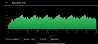
During my last 10km cross country skiing, mostly performed in six laps the altitude chart does not "copy" laps. Each lap is pretty different. Also start and end altitude is not correct. If i disable Elev Corrections, overall data are:

Elevation Correction disabled.
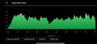
205,0 m
Total Ascent
184,0 m
Total Descent
394,8 m
Min Elev
437,2 m
Max Elev
Correction off
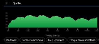
If I enable it it is:

Elevation correction enabled
142,9 m
Total Ascent
143,5 m
Total Descent
397,9 m
Min Elev
437,7 m
Max Elev
Correction ON
And altitude chart makes a sense as well. 
It is pretty big difference. Is it normal? I do not like it...
  • Hi, I've had the 955 for 10 days and I've noticed that with the auto calibration it works rather badly, but using only the night calibration it improves a lot, SW 17.24. The 945 was a complete disaster

  • I run in a 2.2km roundtrip, 7 rounds to a total of about 15km, so starting and ending altitude must be the same (about 216m)

    Calibrated before start with DEM at 216m, it increased to over 240m!

    I suppose it is related to temperature: started from my home and went outside with snowfall

  • Hi, thank you! I will try it!

  • I think its related to temperature. I've noticed that as the watch temperature decreases, the elevation reading will increase. I made a similar post last week (here). 

    My elevation consistently drifts upward during activities (it is cold here this time of year) and the start/end elevation never match if I start and stop in the same place. I always calibrate manually (or to DEM) before each activity too. It kind of sucks that this happens to the high end Forerunners. I think the Fenix's are definitely better for some reason (I had a comparison in my post). I have also been looked at some friends Strava elevation graphs (that use the Fenix's) and they usually start/end at or very close to the same elevation.

    To "fix" this, you could manually re-calibrate the elevation during the activity (for example at the start of each loop), but 1) that is pretty inconvenient and 2) if the elevation drifts upwards and you re-calibrate back down to the correct elevation, the watch still wont subtract out the false elevation gain (caused by the drift), so the total ascent number will still be incorrect anyways (too high in this example).

    (To re-calibrate elevation during activities, add the Altimeter to the Controls menu, then you can access the Controls during an activity by holding the Light button. It wont pause or end the activity)

    Garmin support said to clean out the sensor and I have been cleaning it every few days, but the elevation is still not correct. I might try to reach out to Garmin support one more time later this week. Maybe if this issue starts affecting body battery or sleep score they will actually want to address it (sarcasm).

  • I get pretty good results with my 955 and they are also comparable with other watches. So there always have a difference of a few vertical meters between different watches and manufacturers.

    For example my last XC round. There is a difference of 12m between start and end and there will also be some impact of the ambient pressure which might be changing.

    I also did a mountain hike (Watzmann) earlier that year and the results were also here pretty good.

    Nearly zero delta (1m) at the end.

    So in summing up the barometer should provide pretty good results but you always will have some drifts due to changing ambient pressure conditions.

    As I have read of a lot of problems with the altitude measurement - I think there might be devices with faulty barometric sensors. Otherwise I can not explain that different experience.

  • Would you compare the elevation with elevation correction on and off for me?

  •   

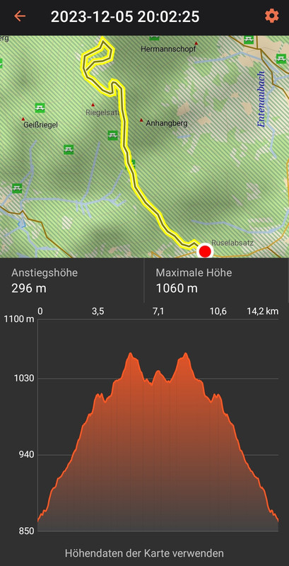
    So I took is from the explore app since I was not sure if it was changed correctly in connect.

    For all my activities the recorded elevation of the watch and the calculated one via the map height model look pretty similar.

    Depending on the route somtimes the measured elevation somestimes the calculated one is higher. But basicly the scheme always "matches".

    In your case you would not even recognize that you did the same tour...

  • Well I have found that there is a big influence of wind (what makes a sence). I use watch on my jacket (with HR strap) and it was windy. If I use watch under my jacket, or sleeve it looks much more precise. I have also took a long bath to clean the baromether apertures, it also helped. No the results seems better.

  • I have replaced my unit for brand new and it has been solved. It works now