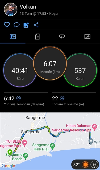
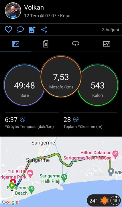
Hi all,
Same route, same road, same distance.
The route length is 7K.
But what I notice in running is that the GPS decreases the distance as I speed up and increases it as I slow down.
What is your opinion? 

Turn off 3d distance.
People here are trying to help, normally it doesn't encourage anyone to help if you're reacting like that.
These stupid questions are right questions. Just read a bit how GPS systems work, how…
What GPS setting did you have it on? It can make a big difference.
The 955 has five different GPS settings, and they each behave very differently.
My experience is simple actually.
1) 3d is a crappy setting - tried several times, speed was all over the place. Being curious i read about how GPS works and learned that elevation is way less accurate reading compared to position (since position may be accurate to 5 or to 15-20 meters, elevation being times less accurate may fluctuate like ***). I believe that's why Garmin uses barometer, not GPS reading to get climb scores/ accent/ decent.
2) Gps is inaccurate in nature. Just record a clean track staying (position will be all over the lace), or try to go MTB hill climbing like 6 kph - you'll get loads of auto pauses (and that's why they include speed sensor in edge MTB bundle)
3) if signal is lost - watch will continue counting (and that's what I'd expect it to do actually). I had tracks with only like 2 first k's recorded with GPS, then lost and still distance and km marks were close to spot on (I use footpod though to get predicted pace).
4) high buildings may lead to loss of signal or tracks curved a lot it even 500m jumps/ cuts sometimes. Same applies to rain and forest (worst is forest during the rain). Had couple of times that signal jump during intervals - really annoying.
3-4 is actually how weather may affect, it does make sense to see tracks in some 3rd party app. My bet for your recording is either signal lost somewhere or wobbly signal that was cleaned by the watch/ Garmin connect. Actually some time ago I saw cases when Strava reported different distance then connect in the same track. Looks they changed something.
Anyway good luck.
I thought 955 uses its altimeter for 3D data, doesn't it? If no, is it known why?
Barometric height should be accurate to the 0.1 of a meter in short term (which activities are).
If the activity is longer than say 1 hour, it should be easily corrected in the long term by averaged out GPS data
Does make sense.
Actually never tried to analyse where from data comes to 3d, just turned it off after nasty experience.
Ps. Not sure if they average anything, at least I saw several times how data fluctuate, same hills getting higher and higher and higher with every lap. It was an old device I assume (520 or 935 or even 920)