This discussion has been locked.
You can no longer post new replies to this discussion. If you have a question you can start a new discussion

missing directions arrow in rountrip course

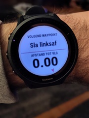
Hi, I've noted this potential bug today, while running in  an unknown area during a business trip. I asked garim to calculate a rountrip of about 10k and that's what the watch did. But immediately after having pressed the start button I did realize the arrow with the next indication was missing, only the distance was on the display but I had to look at the (tiny) map to understand where I should have turned. pretty much annoying, especially for me and for those of my age having some issues seeing the tiny map on the display. Anyone experiencing the same?

thx for reporting here.

andrea

  • I do not know about the arrow, but I can tell you can zoom in on the map, so it is not tiny anymore:-). Another workaround is to make a new datafield with directions. I have set mine to tell me in words what to do, so Right, Left a.s.o. with the distance to the next turn.

  • zooming is an option but of course not my favourite, since that would mean to stop running and dealing with the zoom and f you are running in a city is like to stop running very often. 

    I'm rather more interested in you second trick, the datafield with directions; how did you make it? can you try t explain me step by step?

    thx

  • Why do you have to stop everytime? Just at the beginning zoom to the right level (press and hold "Up", zoom with "up" or "down") and zoom level will persist during your activity.

    Anyway, this is how text directions look like in a data screen:

    Maybe your Dutch is not so good ;-), so translation: Next waypoint - Turn Left - Distance to next - distance in meters

    How to:

    - select activity but DO NOT START IT

    - press "up"

    - select "settings for <activityname>

    - select datascreen (or data field or something, mine is in Dutch so do not know English terms)

    - scroll down to last field with the + to add datafield

    - select adapted datafield (or "other field" or whatever it is named), it is the first choice in the list. Select the layout (one fiels/two fields etc)

    - select the field and scroll through the menu with all types of data to the menu of "navigation fields"

    - I selected "next waypoint" and distance to "next waypoint" in the above screen

    good luck

  • thx for the explanation; btw I've sent also a private message before reading here you answer...ignore it.