This discussion has been locked.
You can no longer post new replies to this discussion. If you have a question you can start a new discussion

Can I force the Forerunner 945 LTE to generate a turn signal at certain points when navigating by following a pre-planned route?

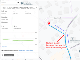
When I pre-plan a route and then follow it in navigation mode during a running or walking or hiking activity, the problem is that my Forerunner is not giving any "turn signals" unless the turn is really sharp, like 90° left/right or so.

So e.g. if I arrive at a Y-shape cross-sections and the pre-planned route turns e.g. 45° to the right into a side-road (instead of following the main road straight ahead), I won't get any turn signal and will miss the turn.

I am wondering: When creating the route, is there a possibility to label or tag certain way points with a property that telles the Garmin watch "here you have to give a turn signal, even if the turn is not very sharp".

The whole problem occurs because the Garmin Forerunner apparently is not aware of streets in navigation mode, although it displays the street as a map on the watch's display. But logically, this only seems to be pixel graphics that the watch is not associating with the route to be followed. This is why in the given example situation it does not give a turn signal. It jsut doesn't know that there is an Y-shape crossing and that the person (me) should be directed in one direction via alarm to walk/run the right way.

Of course, if there was a possibility to make the Garmin aware of the streets/ways and generates a turn signal more frequently during route navigation, where necessary, this would be great.

----------

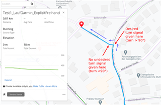
Update: Meanwhile I realized that there *is* an option to tell Garmin to guide me along the streets of the map material, i.e. put the route onto the street net, so to say. However, this comes with many other deficiencies and is therefore not a viable option:. Deficiencies of this mode are:

- Forerunner does not warn me if I miss a turn and deviate from the route. Instead, to make things even worse, it "invents" a new route that is very far away from the pre-planned route (relaly with no relation to the pre-planned route) and wants to lead me along that route, not even warnign me that this is not my original route.

- If I missed a turn and then realize it 300 m later and walk back to the pre-planned route, the Forerunner still does not realize that I am "back on track" and wants to guide me in random completely implausible directions - absolutely crazy.

- Often, althouth I am Navigating right along the pre-planned route, the Forerunner suddenly deviates from this route without any reason! Often, I should turn left or right into a street, according to the pre-planned route, but the Forerunner wants we to go straight ahead. This defies the whole purpose of navigating along a pre-planned route.

Bottom line: The navigation along a pre-planned route in combination with a map match mode is completely unusable. (unfortunately, the mode without the map match is also unusable, just for other reasons.)

  • Next code makes the datafield invisible. Till 85m to the next point it will do nothing. At 75m from the point it will give an alert and when the distance is lower then 10m it will give a second (different) alert. You can easly change the distances by changing the variables.

    setv(1,85);setv(2,75);setv(3,10); Ifs(distanceToNextPoint_raw eq null, "", distanceToNextPoint_raw gt getv(1), "", distanceToNextPoint_raw lt getv(1), alert(distanceToNextPoint_raw lt getv(2), 4,0); alert(distanceToNextPoint_raw gt getv(3), 0, 2))

  • This looks great.

    What action does the "4" stand for, by the way? Acc. to documentation (ciq-appbuilder.blogspot.com/.../functions.html) I think only 0, 1, 2 and 3 are defined...(?)

    And I have some more ideas:

    (1) One idea: [Update: I had misunderstood "distance_raw" from the docu, so this idea has become pointless. Hence "greyed out", since "strike-through" formatting is not available.

    From reading the documentation on https://ciq-appbuilder.blogspot.com/ I understand that "distanceToNextPoint_raw" relates to ANY waypoint (or "course point", as Garmin calls it), whereas "distance_raw" function only relates to special "Aid Station" course points (ok, seems somewhat arbitrary, but ok...). Now my idea is to set Aid Stations where I want to turn RIGHT, and another other course point where I turn LEFT.

    So for "Aid Station" course points both functions "distanceToNextPoint_raw" and "distance_raw" would trigger, whereas for other course points only the "distanceToNextPoint_raw" would trigger. So it should be possible to build a formula that e.g. beeps once upon left-turn (some "other" course point) and twice upon right-turn (Aid Station course point).]

    (2) Another idea, requiring only one sort of course point, is to place the course point e.g. 20 meters after a turn of the route, and then, in the formula, use some suitable combination of the "Bearing" and "CourseOverGround" variables. Then depending on whether Bearing is greater or smaller than CourseOverGround, one could build a formula to beep once or twice, respectively, to indicate the turn direction (left/right). Of course this only works if the "Bearing" variable relates to the "next coursepoint" and not to the "final destination". I don't know if this is the case (otherwise one may feature-request a new variable "BearingToNextPoint"). Unfortunately, at https://ciq-appbuilder.blogspot.com/p/variables.html the link to the detailed information on Heading and Bearing and CourseOverGround is broken (empty).

  • I only use track mode, switch the turn alerts off, turn the warning from course on.

    I plan routes with locus map and send them with locus map for Garmin.to the Forerunner. Routes planned 100% with locus works great. Gpx's who are modified with Locus not always...

  • I installed the AppBuilder and tried out the variable distanceToNextPoint_raw in a very basic manner - I made a "formula" that consists of only this variable in itself. But it does not work, it just outputs !Name. Any idea?

    The description incl. screenshots is here:

    forums.garmin.com/.../connect-iq-appbuilder-5-almost-nothing-works-on-forerunner-945-lte

  • setv(1,85);setv(2,75);setv(3,10); Ifs(distanceToNextPoint_raw eq null, "", distanceToNextPoint_raw gt getv(1), "", distanceToNextPoint_raw lt getv(1), alert(distanceToNextPoint_raw lt getv(2), 4,0); alert(distanceToNextPoint_raw gt getv(3), 0, 2))

    Hi Kroez_control,

    did you try this out on a FR 945 LTE to really work? Or do you have a similar watch (maybe the FR 945 "without LTE"?)?

    Because, what I wrote, and what I described here in more detail - and acc. to the reply from the developer of AppBuilder himself - it seems that distanceToNextPoint_raw, which is part of your formula, is not wirking on the FR 945 LTE.

  • The formula works on the normal 945. I am using appbuilder 5.

  • Back to my original problem: I now found a way (workaround) to ensure that turn signals will be given at critical locations on my course when navigating along a pre-planned course in the "Follow Course" ("German: "Strecke folgen") setting within the Routing settings of an activity.

    Side note: I strongly prefer the "Follow Course" ("German: "Strecke folgen") setting over "Use Map" ("Karte verwenden") setting due to severe bugs in the latter mode (compare (M4) to (M8) in this German post), like: Not warning when leaving course, not re-locking on the planned course when back on this course, random nonsense navigation orders instead of following the pre-planned course.

    The workaround goes like this:

    When I plan a course in Garmin Connect in the web browser (or in the Garmin Connect app), I am "fine-tuning" the critical turns that are less than 90° but where I want to ensure a turn signal, by using the "Freehand" mode and designing the course, on "micro-level" so to say, such that a >90° turn is included at this location.

    I achieve this by including >90° "micro-turns" that will cause the watch to generate a turn signal. I have tested this and it works as expected - see the following rather self-explanatory screenshots from Garmin Connect in web browser for illustration:

    (needless to say that this increases planning time by factors and is hence a rather cumbersome workaround...)

  • Check out locus map if you have an android device. Can do the same and more :-)

  • Thanks. Interesting, and I'll have a look for another use-case.

    But for my primary use-case, I am running with my watch on my wrist and without any additional Android device in my pocket (I leave my smartphone at home when I go running).

  • For my suggestion: indeed only the flag shows up. (why @garmin doesn't also reproduce the label is beyond me :). What you have to do then is look closely at the map itself. Any label you type, like " TURN RIGHT"  will show up on the map at the marked location. Garmin offers multiple types of Waypoints. I just use the basic one. I get the flag and beep and glue my face to the map. It shows up there no matter what my label says. (yours could say "c'mon Garmin"). That's why I have the label in all caps. A bit easier to read on the small map. Also note that the way point alert only shows up when you get close to the point, as opposed to a proper turn that shows up the minute you finished the previous turn.