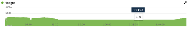
This discussion has been locked.
You can no longer post new replies to this discussion. If you have a question you can start a new discussion

+607 feet ascent from track running

Uncorrected, +607ft

Corrected through Garmin Connect, +889ft

This was an interesting occurrence with the altimeter from today's track run. I live close to a track and run there for workouts. The total elevation gain might be around 25-75 feet by my calibrated eyeballs. Nothing serious. 

I've wondered how they estimate elevation gain because it's just not very accurate in practice.

  • Elevation correction uses topographic data (elevation at different positions).

    Check the logged positions. It looks like you had a small ascent every loop. With ~30 loops it adds up. 

  • are you saying that your track has a real gain by eye of 25-75? That is quite the range... and also quite the hill on track, every track i've ever seen is flat - 0 ft!   hmm  But like Andy says - 28-30x small hill loops make for some quick elevation gain even on a small hill.  28(?)loops x 30ft... is 840 feet.  You can see some temperature effects which is typical on the elevation.... i often will keep coat off of my watch to let it get cold a bit before hitting the start button.  similar with bike, will strap it to handle bars while it is in the garage for a while before ride.  

    If you are saying that in total your workout should have been 25-75... then that is weird that it would be that messed up.  but could be the auto-calibrate feature based on the topographic mapping data is so far off... that skewed things.   but i'm not so sure how that workss.

  • I live close to the track and run there, so some very slight elevation changes traveling to and from. And yes, being a track, it is nearly flat. That's why I believe the real elevation gain should be somewhere between 25 and 75 feet.

    Additionally, last year I purchased the TOPO 24K Map for my region thinking it might provide additional resolution to the DEM mapping on the 945. Unfortunately, it seems to be only a graphical layer.

  • I have something similar on the track where I usually run. According to the map and to my watch, there is about 1 meter elevation difference in the track. In real life (I don't have calibrated eyeballs Wink), it's a flat as a pancake. However, there is a building on the far end of the track where the wind circles around, usually resulting in noticable stronger head-wind in that specific corner. That is also the corner that is 1 meter higher. As the watch uses the barometer, it might read the change in air pressure (due to wind circling around the building) as change in elevation.

    A lot of Garmins elevation data is based on elevation readings from activities measured on devices with a barometric altimeter. At my running club, roughly 80% of the runners uses a Garmin watch and most of these nowadays have a barometric altimeter. That means that Garmin gets a lot of consistent data that tells them that this specific cornor of 'my' track is 1 meter elevated opposed to the rest of the track. Because of the many reading from many different devices and users, Garmin sees this a consistent data. That's why it also reflects in the corrected elevation.

    Long story short, if there is a building (club house or something similar) relatively close to the track, it might influence the barometric pressure on this specific point.

  • It's an interesting theory. Even odder: The Bike activity records elevation correctly or at least reflects the elevation closer. This makes me think that Run and Bike have two separate altimeter sampling algorithms. 

  • That indeed is interesting. Makes one think. Deriving altitude based on barometric pressure difference should be the same across activity types, I figure. Otherwise hiking, running and cycling the same route would delivery different elevation result, where as in real life the course is same.

  • Were you recording this with the Track Run activity, or just the regular Run?

  • These experiences are recorded with regular run app. The track run app disables elevation on calibrated tracks. Distance recorded with with the track run app outside of the calibrated tracks elevation is recorded. Hence, the track run app assumes that a track is flat. Below an example of a recent track run, where warm-up and cooling down are outside of the track and the core training is on a calibrated app: