This discussion has been locked.
You can no longer post new replies to this discussion. If you have a question you can start a new discussion

Barometer elevation accuracy degradation over time.

Hi everyone,

I wanted to check in and see if anyone else has experienced the same issue as me...

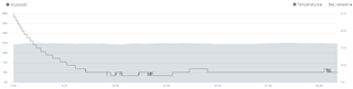
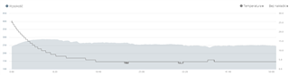
I first purchased a Forerunner945 in August 2019 (just after it came out), and for running and cycling had great accuracy for elevation.  Slowly it degraded in accuracy until by August 2020 I was seeing nearly 100% extra elevation gain / loss on a 2 hour cycle - and Garmin replaced the device.  I have now been running the new 945 for 9 months or so, and have started to see exactly the same effect again.  Its less pronounced, but headed in the same direction.

I am working through this and the same support process (I share my commute cycle - one hour each way, they tell me its "within tolerance"- I show how its changed again etc) but expect it to keep degrading again.

Does anyone else have the same issue?  I don't see why I should need to use Elevation Correction for every commute to prove to myself I'm not climbing a mountain between my home and work.....especially as it used to be spot on.  Also feel free to say if your device has been perfect for two years!  I use mine 4-5 times / week for swimming, running and cycling, so gets a reasonable, but not excessive amount of usage.

Many Thanks!

  • That probably depends, I would guess that's the reason there's a setting for it.

    Like if you are doing a long activity and the weather changes and there's no calibration, it starts to get it wrong.

  • Hi,

    for me the best test is to check altitude widget after your night sleep. When device works correctly, your elevation chart after your night sleep (last 4 hours) is definitely flat (the highest and the lowest elevation points are the same). When device goes crazy with sensors, after the night sleep, in the morning, widget from last 4 hours shows completely different the highest and the lowest elevation points and chart looks like your activity in the mountains Slight smile It shows an issue with temperature sensor.

  • That would still depend on the weather and the atmospheric pressure as it is possible for the watch to detect movement and combined with change pressure to think that you're actually climbing. The best way is to watch the atmospheric pressure itself and to compare it with another device as a relative change and difference applying also the percent of error and deviation of the devices.

    Altitude is just a result of reference value mapped to the atmospheric pressure, considering also the temperature - so it is an algorithm that calculates it based on a different data and so it can not be used for correct measure of accuracy and health of a specific sensor in our case.

     I did an experiment yesterday as I had to drive to the sea. So I usually live in a city that's around 500m altitude. There is a specific point scientifically measured in the center of the city with the exact altitude written on it. So I went there and calibrated it using also the nearest weather station for mean sea lvl pressure calibration. The next day I drove 400km to the sea lvl and measured the altitude form the watch on the sea lvl. It measured 15m which was really really accurate considering that went through different weather, pressure and temperature changes and more then 24h of time between calibrations. GPS usually will fu** any accurate calibration you might have done. As 3D navigation is prone to a lot more(geometricly more errors) - that why your car gps and any other gps needs(including the map on your watch)  DEM map as gps just draws the coordinate on a sea lvl line and then altitude is mapped through an integrated(in case of car navigation) DEM data. 

    In the case of our watch it's highly depends on the use case and settings what will be used for altitude. Usually DEM is only used for measuring the distance and for navigation while the data for live showing of climbing (climb pro) uses the pressure sensor (hm on second thought for accurate working of climb pro it should definitely use the track or DEM elevations).... Anyway you got my thoughts

    All in all don't expect military lvl accuracy from a device on your wrist with a size a little over a coin and for that lower price(altho it's fu**** expensive for an ordinary person).  You'll be stunned by the price of the devices that civil engineers use for altitude measuring - if it was that easy they would have simply use their watches and not use bank loans just to buy the devices. 

  • Former Member
    0 Former Member over 4 years ago in reply to 2705126
    What would the best settings be for auto-calibration? At the start/during activity - not during activity?

    Just as jmto said, it depends.  I'll share my settings and then explain why

    Calibrate at start of an activity.  NEVER.  I always manually input the correct elevation prior to every workout.  This information can be easily found on the Internet using your phone or computer.  If I forget to look it up for some reason, I wait for a good GPS fix and calibrate using DEM as my second choice and because GPS can have an  elevation error up to + or minus 400 feet, this is a last resort.  On top of calibrating my elevation, I always check the pressure readings for my start point and calibrate my barometer also.  This information is also available on the Internet too.

    Calibrate during an activity.  DEPENDS.  I change the barometer mode between altimeter and barometer depending on the environment my activity is taking place and turn calibrate during an activity to off.  The only time I'll use it if both my course has a lot elevation changes and I'm expecting the pressure to change during the activity.

    Calibrate not during activity.  NIGHTLY.  A lot of people don't understand this is a one time calibration and doesn't happen 24/7.  You have to have a Bluetooth connection to your phone, Garmin Connect Mobile running in the background and a set sleep window.  During you sleep window, your watch will use the GPS location it receives from your phone and then calibrate your watch to that altitude using DEM.  It works great unless you sleeping on the 20th floor of a building (it calibrates to ground level) and you don't have to worry about starting your day by calibrating.

    It works perfectly for me and I've had my watch the weekend the 945 was released more than two years ago.

  • Hi,
    everything is true, but you say like Garmin: "This is not a NASA device but fitness device only" Slight smile OK I accept it and agree but then I have a question: why during first 3-4 months everything is ok, sensors are able to measure elevation on correct level and exactly after 4-5 months sensors go crazy and show strange values? I asked them about it and they were not able to answer it. They had to exchange my device to the new one. And I'm not saying about a few meters. On track with maximum 10-15m elevation gain during first 3-4 months, exactly after 4-5 months it shows 200-300m elevation gain. This is definitely problem with broken sensors.

  • What i meant is to not focus on the elevation but rather to check the data from the pressure sensor and compare it. If the data is ok then it is not sensor issue but rather a software one - maybe DEM on your map gets wrong or on specific months because of the weather or gps satellites it brings more error. It's only one sensors that is used for elevation measuring and it is the atmospheric pressure sensor. If it is good then look elsewhere...

  • Hi,
    also second sensor - temperature is very important to measure changes of your altitude. That's what I wrote earlier. You can test it in your bed or leave device in cool and warm place. When device is OK, it doesn't matter how temperature is changing, altitude will be always the same. But when device is broken, any little changes in temperature also change your altitude. Of course atmospheric pressure sensor is also involved into this process but with cooperation with temperature sensor.

  • Yes but I'm pretty sure it would not count the temperature from the sensor in the device since that temperature changes a lot.. and i mean a lot. I think it get's the latest temp for the area and as a fall back uses that sensor. Also the temperature usually when it's 0 C outside - on your hand will be around 20 to 10-12 depending if you have cloths on it(which could be a difference of around 200 meters). That's why I'm pretty sure it doesn't use it and uses a combination of DEM data with pressure data and probably weather info from nearest station(if you have connection). As the difference is not that big on the temp I guess if you calibrate it before activity and the use accelerometer to map on the Y axis combined with pressure change data for a fixed temp it might be accurate enough.

    In the end just test both sensors separate. Temp is easy enough... pressure will be more hard but still doable. If both are ok then the issue is somewhere else and it might not be connected to the device at all. 

  • In my opinion it is for sure correlated. Here you can see the same track and two runs. First when device is new, second when device has about 6 months. Always for every run first approx. 15 minutes is affected - huge gain of elevation, the rest of time in every run seems to be ok. The same for model 935 and 945 and not only with one device.

  • I have the same problem. My FR945 worked perfectly, but suddenly the elevation data is completely off. I did a bike tour, which should have around 600m of elevation, but it showed me over 3000 Open mouth Would be nice, if i really did this Joy I tought it's maybe a software problem caused by the 7.2 update, but i couldn't find any other reports regarding this issue based on the 7.2 update. So i just hope to get a new/repaired device from Garmin.