This discussion has been locked.
You can no longer post new replies to this discussion. If you have a question you can start a new discussion

Benefits of the Topo 24K maps?

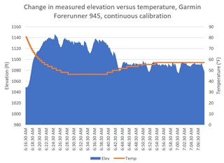
I'm trying to understand how elevation works with this watch. I do morning runs in sub-freezing temperatures, and it makes the elevation profile very inaccurate as the watch cools down. From what I can tell, the association is Δ temperature = -Δ elevation. 

I purchased the Topo 24K for my region to have better elevation data. Theoretically, the 24K topo maps have much higher resolution elevation data that the watch should be able to benefit from. My assumptions are that it should be given the additional granularity by the Topo 24k maps. What I fear is that the 24K topo map is nothing more than a visual overlay. 

Calibrating the Altimeter can be done via DEM. The question is, does the DEM mapping become more granular with the 24K topo maps? I've turned off all auto-calibration of the altimeter during activity to force the watch to use map data for elevation. I'm hoping it uses the Topo 24K map data if my initial assumptions are correct. 

  • Nope.

    Your watch calibrates with DEM (so using the data of a map) either manually or auto (if this is enabled).

    The way you setted your watch: you disabled auto calibration during the activity --> the watch gives you a "pure barometric altitute data", I mean that it uses only the barometer in order to catch altitude data.
    So you are supposed to manually calibrate the altimeter before the activity.


    So your assumption is wrong: the watch will still use the barometer in order to catch the altitude data, but disabling the auto calibration during activity simply it won't "correct" your altitude data using the ones from the map assuming your position with the GPS.


    P.S. Sorry but it's difficult for me to write difficult concept in English, since it isn't my first language

  • To be specific, this is from the .FIT file. This result is from six laps on my regular course. The data presented in the graph suggests there is a temperature dependency with measured altitude. 


  • Of course there is a correlation between barometer and temperature, during the first Italian lockdown I ran up the stairs of my building, at the time I used FR645M but I think it is similar to the 945, the first 2 steps I counted the right plans but then warming up my wrist began to make mistakes the count and decreased.

  • Background:

    Similar to how Garmin Power works, if the "Power" ConnectIQ data field isn't enabled, Power won't be recorded even though Garmin Power is installed. The Map data screen must be enabled for continuous auto-calibration to work. 

    The fix:

    Make sure that the map is an enabled data screen. 

    Discussion:

    The altimeter gives the option for calibration via three pathways:

    1. DEM (digital elevation maps), which contain precise elevation data from topographic surveys. This is highly accurate data but can change over time. 

    2. GPS is different in that it calculates elevation data based on timing calculations. The drawback here is that the signal bounces around and isn't exactly a straight line from the satellite to you. That variation in time of signal travel limits the accuracy of elevation data.

    3. Manual calibration. Some people might have access to surveying equipment or other means to accurately measure current elevation, which could be a good option. 

    Without the map data screen running, the altimeter cannot auto-calibrate during activity. Note, it doesn't need to be running actively on the screen.

    Topo 24K Maps:

    Going back to the original question: What are the Topo 24K maps good for?

    The Topo 24K maps enable isolines on the map with elevation data. I don't believe that they change or upgrade the DEM data provided via the DEM Basemap, although I could be wrong. The added isolines provide the user with additional information and could be a potent tool for trail activities. Without it, maps will not display topographic data. During activities, Altimeter data lines up with the topographic map data, confirming that elevation data is coming from the map and not solely barometric data.  

  • Former Member
    0 Former Member over 4 years ago in reply to ss29640
    DEM (digital elevation maps), which contain precise elevation data from topographic surveys. This is highly accurate data but can change over time

    I agree that DEM has the best elevation data of the 3, but it's only as good as the most recent survey and map update.  Garmin keeps up on maps as far as streets, trails, etc., but I don't know how often surveys are conducted and updated.  For example, I purchased the Birdseye Satellite Imagery maps.  When I zoom into those maps of my neighborhood, I see a vehicle in my driveway that I sold 8 years ago.  Google Earth even shows an older vehicle I use to own.  I also tried to download a map of an area I was going on a hunting trip to in another state only to find the map was surveyed in the winter and the ground was covered in snow and did me no good.  It makes me wonder how often DEM is updated. 

  • 1. DEM (digital elevation maps), which contain precise elevation data from topographic surveys.

    And Garmin is using bad DEM data globally. It might be good somewhere but in other parts of the world their data is bad. They also force elevation corrections to all courses that go via Garmin.

    There many discussions asking for Garmin to fix that data, but they doesn't seem interested. That bad data makes things like PacePro unusable. (Also they could make the PacePro differences in pace to be allowed to be bigger that it would be usable in trail running, but still again no).

    No idea how old it is, but it's unaccurate and bad. There's a lot of discussion about it, but nothing from Garmin.

    For eg. this https://www.dcrainmaker.com/2020/05/garmin-launches-strava-komoot-route-sync-works-on-devices-a-decade-old.html#comment-3562253 

  • I'm more concerned with elevation changes, more so than absolute differences. The barometric elevation data is too sensitive to temperature fluctuations to be useful. I live in a hilly area, and the DEM data reflects the terrain far better than the barometer does. It could be that the 24K Topo map changes elevation data, but, I don't know. There is no technical information on how it works.