This discussion has been locked.
You can no longer post new replies to this discussion. If you have a question you can start a new discussion

Elevation Problems

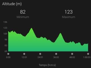
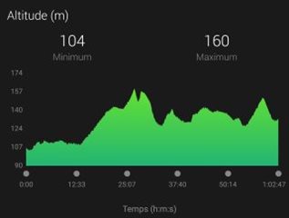
Recently (last few weeks) every activity records a significant climb in elevation for the first several minutes before settling back “down”.  Running and cycling.  Most of my routes begin wit a slight descent, so I know something is wrong.  The starting elevation seems right - this is not like the failing barometer problem where the watch thinks it’s at 60,000 ft or something.

ky 945 is only about 6 mos old.  Does anybody have similar issues or know of a solution?

Thanks.

  • Former Member
    0 Former Member
    1. Yes, I have same problems when I use run activity.
  • When did this begin for you?

  • Former Member
    0 Former Member in reply to dwells2009

    3 weeks ago about. I am on 4.40. Today I run 15 km and when I checked GC I seen at Climbing card 34 up 32 down! In reality is only 1 up and 1 down...

  • Former Member
    0 Former Member in reply to Former Member

    I run on flat at 108 m ... Before FR945 I had Fenix 5 but no any problems like this...

  • Former Member
    0 Former Member in reply to Former Member

  • Former Member
    0 Former Member in reply to Former Member

    Running and Cycling did on same route 108 m Today.

  • Former Member
    0 Former Member

    Problems with elevation (and stairs) to.

    On a flat trail it's reporting 225m.

    And stairs is reporting 108, but in reality it's just around 12.

    It counted almost perfecly before.

  • Hello, I agree with you.

    For me, it's due to the GPS accuracy.

    Setting : GPS+GLONASS
    Covid19 restriction in France : I have to run in the city (so, buildings and trees)
    Accuracy of GPS : 20-30 meters in this context (it's important to take into account that)

    My start/end point is 106 meters from Google Earth data.

    Look at this 2 exemples in Run mode (I can provide more...)

    Ex 1 : The start point is too high. Because there is my building at 20 meters and I think GPS take a point on the top of the building ^^
    The watch was adjusted the elevation during the run.
    At the end, elevation is too low, it should be about 106 meters.
    Start or End, I retrieve the magic numbers GPS error : 20-30 meters

    Ex 2 : The start point is perfect !
    But the end is too high : +20/30 meters
    One more time, I retrieve the magic numbers GPS error : 20-30 meters