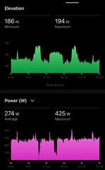
Hi everyone,
i practiced on a cinder track for the first time tonight. The elevation graph is remarkable. It’s the same round every 400 meters. Anyone have an idea how this is possible?
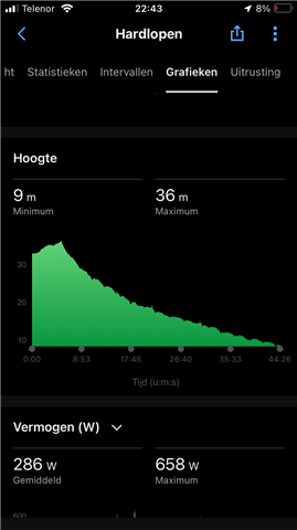
I think that's atmospheric pressure elevation, so the watches think that you're descending.
I see it all the time when I am doing longer activity, I come back to the starting point by the same way and ascending/descending is not the same and I think this is because of atmospheric pressure. You can correct it in web version of Garmin Connect, there is "Elevation Correction" feature in Activity detail.

I am having the exact same issue. I am reviewing my activities along the same route and the elevation had always been accurate until around the start of March. At this point I now have a huge spike in altitude at start of activity.
Always running same route and have tried cleaning sensor / calibrating over and over and nothing is fixing it. Not sure what happened in March that changed things but I am beginning to prepare to move to a new ecosystem if I cannot get this resolved.

This is what my elevation was looking like when things were working properly prior to whatever changed that messed things up. I have been hoping an update was going to resolve it but It has been persisting for some time.
Also along with the elevation issue I am now ascending 50+ floors per day even though I am walking mostly flat ground in my workplace.....