This discussion has been locked.
You can no longer post new replies to this discussion. If you have a question you can start a new discussion

Calibrate Barometer Instability it's fluctuating not stable...

Hello,

Have a serious issue with Calibration the Barometer with GPS it's altitude is fluctuating and it's not ok...proof here:

Did hard reset, restart sync(wi-fi, garmin connect, express) no fix at all

Barometer(not stable..it has big deviation more then 70m) I did test the barometer in the service menu all ok...maybe it;s software 5.33 with bugs

Do you have the same issues with Venu 2 barometer ?

Top Replies

All Replies

  • Not now but it can be use full in future 

    My Lowes Life

  • I don't really understand what you want to show with the video. An altitude measurement via GPS can naturally deviate by up to 120 meters. This is also described in Garmin support articles.

    „GPS - This mode determines your altitude by GPS triangulation. The altitude calibrated by GPS is accurate to +/-120 m.“

    1 hPa = 8m

    The better method of calibration on the Venu is calibration via Connect App. This determines the altitude to the height of the DEM (digital elevation model) related to your location.

    It would also be good to know how high you really were. Do you know the correct elevation  of your location ?

  • Where did you get this info ?

    https://www8.garmin.com/manuals/webhelp/GUID-D93137A9-B374-4A24-8A4D-A66C9AC91265/EN-US/Venu_2_2S_OM_EN-US.pdf

    in the venu 2 manual is not such info

    Today's GPS receivers are extremely accurate, thanks to their parallel multi-channel design. Certain atmospheric factors and other sources (tall buildings, densely populated areas, etc.) of error can affect the accuracy of GPS receivers.

    Garmin® GPS receivers are accurate to within 15 meters (49 feet) 95% of the time. Generally, users will see accuracy within 5 to 10 meters (16 to 33 feet) under normal conditions.

    https://support.garmin.com/en-US/?faq=aZc8RezeAb9LjCDpJplTY7

    For your reference I did see others Venu 2 and the "fluctuation free"

  • Today's GPS receivers are extremely accurate
    Where did you get this info ?

    GarminRegistered GPS receivers are accurate to within 15 meters (49 feet) 95% of the time. Generally, users will see accuracy within 5 to 10 meters (16 to 33 feet) under normal conditions.

    https://support.garmin.com/en-US/?faq=aZc8RezeAb9LjCDpJplTY7

    The article you linked is about GPS (outdoor/handheld etc..). These devices are much larger and equipped with better receivers.

    Furthermore, the article you linked does NOT refer to elevation, but to POSITION ACCURACY.

    altitude measurement via GPS can naturally deviate by up to 120 meters. This is also described in Garmin support articles.

    „GPS - This mode determines your altitude by GPS triangulation. The altitude calibrated by GPS is accurate to +/-120 m.“

    Where did you get this info ?

    https://support.garmin.com/en-US/?faq=En8Ve2Q5VX7nbFL0Tkuub9

    Accuracy of GPS Elevation Readings on Outdoor and Fitness Devices

    GPS elevation readings from your Garmin device are a good tool for approximating elevation when you are unsure of the actual current elevation. 

    Accuracy of GPS Elevation

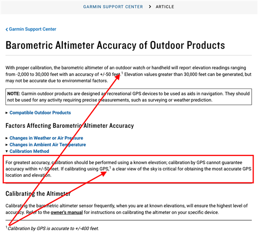
    Elevation calibrated by GPS is accurate to +/-400 feet with a strong GPS signal. 

  • The information you provided GPS is accurate to +/-400 feet is not valid

    https://support.garmin.com/en-US/?faq=WlvNrOungC28xGtwB7hLY5

    Also that is not normal having unstable altitude and fluctuation...

  • The information you provided GPS is accurate to +/-400 feet is not valid

    https://support.garmin.com/en-US/?faq=WlvNrOungC28xGtwB7hLY5

    Of course, my information is valid

    . Please refer to footnote (1) also in the support article you linked.

    Thanks for your link.

    With it you confirm my statement. The article even contains my statement twice :


  • Today's GPS receivers are extremely accurate, thanks to their parallel multi-channel design. Certain atmospheric factors and other sources (tall buildings, densely populated areas, etc.) of error can affect the accuracy of GPS receivers.

    GarminRegistered GPS receivers are accurate to within 15 meters (49 feet) 95% of the time. Generally, users will see accuracy within 5 to 10 meters (16 to 33 feet) under normal conditions.

    https://support.garmin.com/en-US/?faq=aZc8RezeAb9LjCDpJplTY7

    This article linked by you does not fit here at all, because

    1) the watches do not have "parallel multi-channel design".

    2) the statements in this article do NOT refer to elevation, but to POSITION.

    You are confusing elevation with positional accuracy.

  • Also that is not normal having unstable altitude and fluctuation...

    Further, the article you linked also says at the very beginning :

    " With proper calibration".

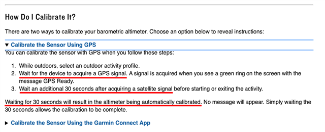
    What you show here in the video, however, is the calibration process ITSELF : 

    https://support.garmin.com/en-US/?faq=LdBgVGQf0b9dILeDnsP189&productID=707538&tab=topics

    The moment you get the green GPS tick, it does not mean that the GPS reception is good.

    The green tick only means that you have GPS reception at all.

    For a position measurement without altitude information (2D) 3 satellites are required. If you also want to have the altitude (3D), at least 4 satellites are required.
    If you ever have the opportunity to look at a GPS device with info page, you will notice on EVERY GPS device that it takes a while until enough satellites are available to provide accurate data.

    In your video it takes about 30 seconds before you even have a green GPS icon. THEN the watch needs another 30 seconds (and this depends on the environment) until the elevation is calibrated.

    This also writes Garmin itself.


    In these 30 seconds AFTER the green tick, it is perfectly normal that the elevation must first settle.

    That's what your video shows.


    If you have seen other devices where this is not so, it may be because on these devices only recently a calibration was made, the altitude has not changed much since the last calibration, or the reception conditions were significantly better.

    I have already described the error tolerance in GPS elevation measurement, and you have confirmed this statement again with your link.

    If you still have problems with the calibration, I recommend you the DEM method via Connect Mobile, which performs the calibration according to topo data.

    If that is also not enough for you, I recommend you to acquire a higher product. With these devices you also have the possibility of a completely manual calibration by manual input of both elevation and QNH (pressure).


  • I had already asked, what was the KNOWN elevation when you took the video ?

    Did you have a clear view of the sky ? Was it cloudy or rainy? Were there trees, buildings, power lines or other obstacles nearby ?

    (Can it be that from second 50 - even earlier - a quite high building is reflected in the display, which is behind you ? That would not be a good GPS condition. )

    Question : was your CPE up to date at that time ?

    https://support.garmin.com/en-ZA/marine/faq/6IbaJEHc1i9gydzQomXzyA/