This discussion has been locked.
You can no longer post new replies to this discussion. If you have a question you can start a new discussion

Totally different elevation numbers depending on how I download the course

I've downloaded a course via three different methods to my Garmin Edge Explore 2. Oddly, each method produces a different elevation gain. I'm curious why the error is so large.

Here are the three methods and accompanying screenshots:

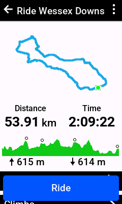
1. I took a gpx trail from Map My Tracks and uploaded it to Garmin Connect on iOS. This then synced with my Garmin device. 615m ascent.

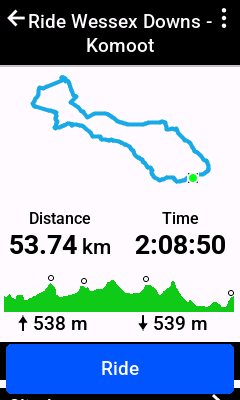
2.  I uploaded the same gpx file to Komoot, which auto-pushed the course to Garmin Connect. This was downloaded automatically to my Garmin device. 538m ascent.

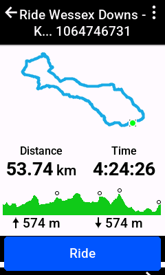
3. I used Komoot's Connect IQ app to download the same route I had uploaded to Komoot in step 2. This time, even the climbs have changed! 574m ascent.

What causes this disparity and what number should I trust?

Thank you!

Top Replies

  • I've downloaded a course via three different methods to my Garmin Edge Explore 2. Oddly, each method produces a different elevation gain. I'm curious why the error is so large.

    The…

All Replies

  • That is a constant issue with any service you use, and it has little to do with Garmin. Each adds different altitude data to your track, and the difference mostly depends on DEM data (altitude grid) that service uses and algorithms to calculate altitude gain. Which one to use? That is a good question.

  • I've downloaded a course via three different methods to my Garmin Edge Explore 2. Oddly, each method produces a different elevation gain. I'm curious why the error is so large.

    The error is not "so large". The biggest difference is 7%,

    You got 574, 538, 614. The average of those is 573.

    The elevation gain is an estimate (which means you can't expect a high level of accuracy).

    The gain estimated from map data ("DEM") tends to be lower because the elevation data has lower resolution (the points where elevation is determined are wider apart).

    GPS can be used to determine elevation but it's not that accurate GPS is really focused on determining horizontal location (not vertical) location.

    The Garmin devices usually use barometric pressure to determine the elevation. Garmin considers this to be the best method but it has issues (changes in weather can effect the results.

    Elevation gain is often treated as a measure of difficulty but it's not that good for that (since it ignores grade).

  • I just did a gravel ride in the San Juan mtns near Telluride, CO where I use the basic Garmin Edge. The elevation gain on the device said I had a gain of 5479'. When I downloaded to Garmin Connect, on my computer, it said 6266'. That's a big difference. It comes out to an 8.7% difference, 800'. I understand, by using barometric pressure, the accuracy can be iffy but why wouldn't it just download what the device says? Which is correct or most accurate?

  • Same issue when I use original map route vs Strava route. If I use original map’s DEM data, there will be a climb pro segment. But using Strava route there won’t be any.

  • Which Edge model?

  • I have the Edge 25