EDGE 840 Navigation completely useless on my unit or location

Hi all.

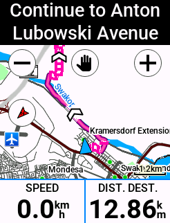
My EDGE 840 navigation feature is beyond useless and downright hazardous. 

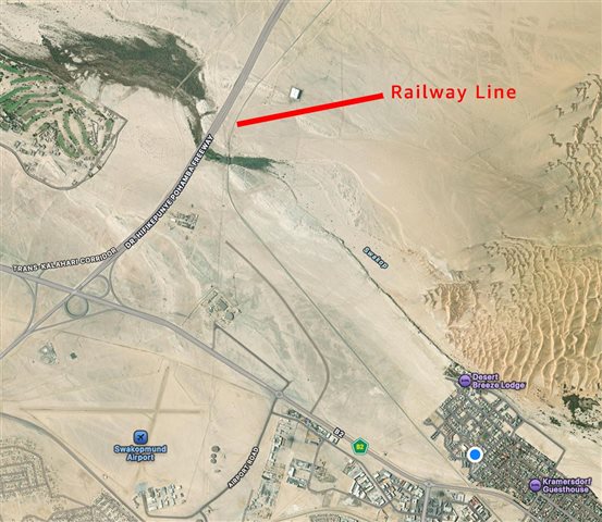
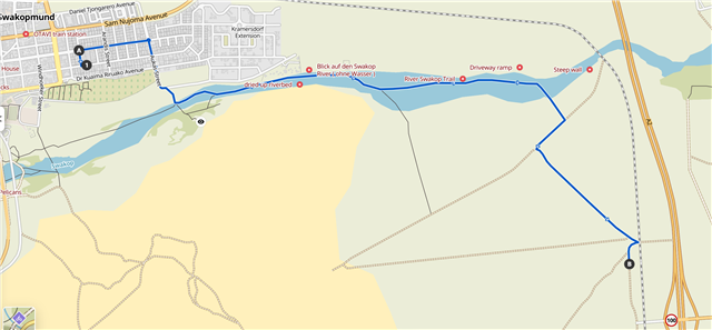
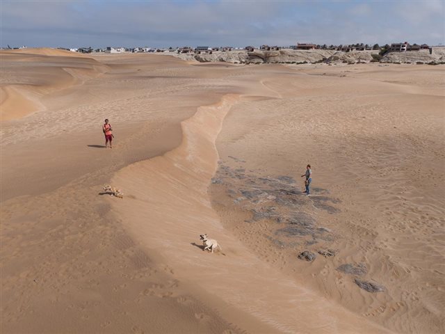
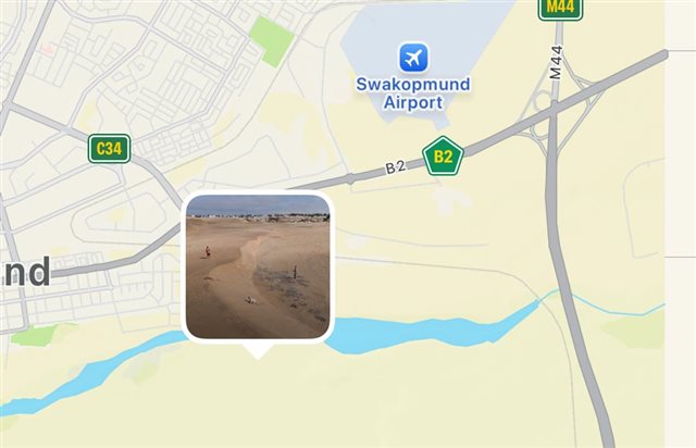
It navigates me within a few hundred meters from my home into a river bed which I somehow need to ride for 4km, then through some dunes, onto an old decommissioned road (6+ years ago) etc...

It cannot navigate me on roads that have existed for the past 20+ years. 

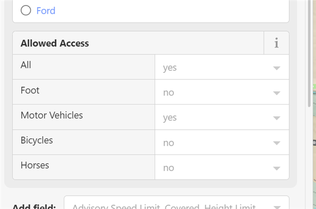
I've disabled enabled all sorts of different routing options. Even having "stick to roads" enabled and disabling popularity routing, does nothing from preventing the device navigating me into Fat Bike terrain with a gravel/road bike. 

It completely ignores highways and main roads that have existed for 5 years or more. 

I've tried with Garmin Cycle Maps, Garmin Topo Maps, and with manually downloaded Open Source maps. All the same.

  • OpenStreetMaps is one of the sources for Garmin maps, if I'm not wrong. So maybe look there, if there is something wrong, it's possible to edit it or ask of edit, repair it, but it takes long time till Garmin reflects it to their maps.

    https://www.openstreetmap.org/#map=16/-22.67676/14.57019

    Also, you can download your own maps right to your Edge 840. So you can correct mistakes in map, download your region right from OSM and use it.

  • Thanks, but like my last sentence reads, I have open source maps (OSM) installed on my device, and it too can't get the device to navigate by roads. 

    All the roads and infrastructure are marked and up to date on both Garmin's and OSM maps, the device just doesn't have a clue how to use them...

  • Just for a laugh, I tried it in komoot too. Similar routing.


    The highway (A2) is indicated in OSM as being barred to cyclists. Are the mapping systems simply trying to give you a way to bypass this?

  • Sure, Komoot uses OSM too. Sorry, I did not read last part in original post.

    I can see that there is a path marked in the middle of the river, so sure it will lead you this way. Martin, if this is not correct, if this is not cyclable route, let's make it not cyclable. Or you can delete it if the path does not exist anymore. About the highways, are you sure you're allowed to use the by bike? I can do some edits, but I need more details from you, because I don't know this place. The best would be to edit the map according to reality.

  • Can you check the settings for the activity profile? Go to navigation > routing and first check if the routing mode is set to road cycling. Then you can try avoidance setup > toggle unpaved roads. And it doesn't address your auto navigation concern, but you could also pre-plan your routes with Strava or Komoot and sync it to the device. Or do imported courses also cause weird navigation?

  • Oh wow, that's hilarious.
    The river doesn't have a pathway.  There are gravel roads between it and the railway just north of it. 

    In terms of popularity routing, there are no cyclists in the river. The routes in the sand dunes, marked in the yellow area on the bottom left, are non existent. Pathways over or through sand dunes don't exist and must have originated from fat bike rides.

    The A2 and B2 roads are the only main roads in and out of town, and it's inevitable one has to ride on them for a short period. Popularity routing shows this.

    If one tries to bypass these roads using the suggested routes, there is not chance one will be able to ride it without 3.5" or wider tyres. 

    There are very alternative gravel routes that ovoid the main roads, but they are not listed, even though they have been here for 6+ years and quite often used using popularity data.

  • Stravas segments and popularity routing

  • Yeah, these are definitely cycle paths that exists.. But I'm not sure how to delete it and probably the many other non existing routes. 

    Road cyclists are forced to ride on the A2 and C28. It's easy to see on a popularity map where we have to cycle. It a large road with a large shoulder. Technically, we probably shouldn't. But there exist nothing as an alternative. Even the suggested road parallel to the A2 to Walvis Bay, does not exist. So why does one have to navigate on a road that doesn't exist.

    Alternatively, I cycled a gravel route yesterday on a service road parallel to the B2. (The B2 has no shoulder so thats just dangerous) This road somehow is impossible to route too. Its existed for 20+ years. 

    I can supply a gpx file for that probably from Garmin connect.

  • I have just marked the river path not cyclable in OSM and asked local OSM editors to look at it and repair the issues in the map.

    Or, as I said, you can do it yourself, if you're familiar with OSM editing or if you're willing to learn it, it's not that difficult. Only you know what's wrong in the map and you're local.

    Also, if there is law that you cannot ride your bike on some roads or highways, it's not possible to make it routable and you should not make it cyclable in the OSM map.

  • In that case, you need to edit the OSM map accordingly; 

    Delete the path through the river bed. 

    Set  "Allowed Access" on the Highway to allow bicycles (though not if it's actually illegal to do so).


    Garmin (and Komoot, and Strava, and all the others) are just using the OSM data. Correct it, wait until Garmin update their maps, and it will route you correctly. I don't know how long this will take. When I edit OSM for my area, the changes appear in Komoot with two weeks.