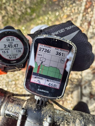
I use a Forerunner 945 and Edge 840 on my rides. Until recently all ascent data was consistent between the two. In the last week the elevation on the 840 has been approximately 50% lower than that of the 945 - with the 945 being correct and in line with the expected elevation. At the same time climbs have been popping up that didn't exist. So I think somewhere the unit has lost the plot (pun intended) when it comes to working out how far I am going up. I have a photo of the issue and a copy of the FIT files from both systems. However, I only have them from one ride as I habitually delete the 840 files to avoid duplicating. I did read somewhere that moisture can affect the altimeter and yes these rides were wet from road spray, not rain, so I will monitor on future drier rides. However, I hope this report allows Garmin to find a solution, maybe allow the software to only use DEM/GPS for elevation and turn off the Altimeter if it is going to be inconsistent in wet weather.


