This discussion has been locked.
You can no longer post new replies to this discussion. If you have a question you can start a new discussion

Navigation fields - Distance to Point / Distance to Next difference & more.

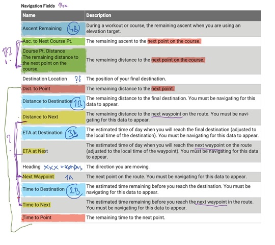
Trying to figure out what do all the navigation data fields do. Some are pretty obvious. Like the "blue fields" (see the annotations of Edga manual below) all of which show remaining time/distance/ascent to the final destination.

But than there is group of 4 datafields highlighted in yellow color - dist. to next, eta at next, time to next and next waypoint. In my understanding they do point to next turn point along the course. Dist. to next even shows small but neat direction arrow. 

But what about those 2 red fields -  Dist. to point and Time to point? I placed all of the fields on one page hoping that I will find difference between the two sets but the only observation I found was that Dist to point and Time to point show dist/time to next turn point ONLY. Whereas those yellow fields will point to nearest course point if there is no turn point before that. Also Dist to next shows previously mentioned direction arrow in contrast to Dist to point which shows nothing but the distance. 

What is the purpose of having two almost identical data fields? Or am I missing something?

And one more confusion - green fields: Course Pt. distance shows distance to my next course point or distance to my course if I stray away from course. According to manual I was expecting the field Asc to Next Course Pt. to show remaining ascent to the course point but doesn't seem to work that way...

Hope someone can clarify this. Coming from Fenix 6x where navigation fields are also bit confusing but after a while I managed to figure out how to take advantage of them. But these Edge data fields look like one big mess :-( 

  • This might answer part of your question

    My understanding is that when a course is created, a waypoint is a specific trackpoint, eg a turn, defining a point that the track must pass through. The course planner also creates additional trackpoints following curves in the roads etc. to define a complete track.  TCX and FIT files contain Course Points that are separate descriptive points, with their own coordinates, along the track that are mostly, but not always, matched to waypoints.

    For example, Distance to Next refers to the next waypoint and Course Point Distance refers to the next course point and may report the same value, but if a course point is moved to 50m before a turn, the values will differ by 50m.

    I don’t know about Dist and Time to point fields (they are not listed in the 530 data fields)

  • yeah, that how I also understand it and my observations confirm it. Difference between "Distance to C.P." and "Distance to next" is pretty clear. 

    But really don't see any difference between the Dist to next and Dist to point. To me they both seem almost identical. 

    However after you mentioned that Distance/Time to point are not in 530 it makes me wonder why did Garmin decide to add them to 540/840...

    Hope more people will share their experience/observations...

  • The way it should work is.

    Distance to point should be the distance to the next unit generated turn instruction.

    Course point distance is the distance to the next course point.

    Distance to next is the distance to next navigational event, this could be either a course point or a unit generated turn instruction. 

    In summary you have distance to the next course point, distance to the next turn instruction and distance to whichever of these is next.

    There are currently a few issues with some of the data being reported that have tickets open on.

  • mmmmh - really? One should show distance to the next waypoint.
    The navigation text field anyway shows the distance to the next navigation event.
    But if you plan i.e. a stop on a longer ride, a pub i.e., you like to know the distance to it.

  • My understanding is that when a course is created, a waypoint is a specific trackpoint, eg a turn, defining a point that the track must pass through. The course planner also creates additional trackpoints following curves in the roads etc. to define a complete track.

    The Edges use track files but they don’t use waypoints (in the file) at all. The file just needs to have track points. 

    Some GPS units (not the Edges) can use files that just have waypoints. They calculate a route between the waypoints.

  • Yes, I know that they are actually track points in the file. Garmin still call them waypoints in the User Guide, presumably to distinguish them from other track points.

    “Distance to Next-The remaining distance to the next waypoint on the route. You must be navigating for this data to appear. “

    Thanks for the clarification anyway regarding other GPS units.

  • Garmin still call them waypoints

    This is (likely) referring to the "generated turn points" (that aweatherall mentioned) produced by "Turn guidance". That is, these "waypoints" are not in the file.

    Track points are not waypoints. All the track points in the file are the same (there's nothing to distinguish them).

  • Agree. It would be better if Garmin didn't use the waypoint terminology at all.