This discussion has been locked.
You can no longer post new replies to this discussion. If you have a question you can start a new discussion

Komoot map climb broken

Hi all

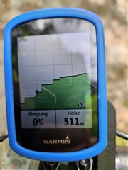
When I import a route planned on Komoot, the climbs are completely shown wrong on the Garmin. Believe me, the road has no right angle climbs, it's a normal road with a fairly steep gradient.

Attached a picture on how it shows on the Garmin. I have this issue since > 1 year, with various firmware updates. 

Do you also have this issue?

This was the planned tour: www.komoot.de/.../1163302459

Thanks
Patrick

  • This is nothing to do with your Garmin.  The elevation data in routes you put on the unit are from the route planner.  In this case it is due to whatever elevation source Komoot use.

  • So essentially, I need to contact Komoot about it?

  • After having a look at the exported raw map data, I think Garmin could also improve their algorithm. There is a location point every few meters apart, which I think is fine, which then causes this. I think the Edge should smoothe this out, when calculating the actual route, so it's not a 90°C step, but actually an incline between the two data points. 

    What they look, for example: 

    <trkpt lat="47.392947" lon="8.586759">
    <ele>498.944929</ele>
    <time>2023-06-11T12:18:29.533Z</time>
    </trkpt>
    <trkpt lat="47.392657" lon="8.585767">
    <ele>507.833812</ele>
    <time>2023-06-11T12:19:05.104Z</time>
    </trkpt>