This discussion has been locked.
You can no longer post new replies to this discussion. If you have a question you can start a new discussion

Elevation issue

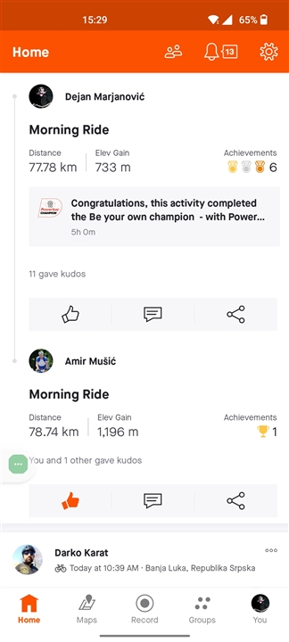
Today I drove with a friend, same route, same length, side by side. In the end of the activity I had an elevation of 773 meters and he had 1140 m.

I use Edge 830 and he has 1030. The difference is too big.

Does any one know what could be the reason? 

Any option to calibrate Edge 830? 

  • Même problème pour moi, avec en plus un affichage incohérent du % Pente (- 15 % en ascension du Tourmalet aux paravalanches de la Mongie, ou + 4% en descente du même Tourmalet).

    Ceci suite à une sortie humide il y a près d'un mois.

    Garmin Edge 830 acheté en 10/2021

  • These bike computers use pressure sensors for elevation data.  They won't be calibrated.  You can't calibrate them.  They are affected by the weather and temperature of the unit.  There isn't anything you can do about any discrepancies.  If you want the same numbers use the option in Strava/Connect to use that services elevation correction.  Otherwise don't pay much attention to the altitude numbers.

    This is true for any bike computer with a pressure sensor, not just Garmin units.

  • They use pressure sensors, indeed. They can be calibrated though: when you are at a location with a known altitude, e.g. a mountain  pass, railway station, your home location, then you can manually correct the altitude indicated on your edge to the known altitude.

    The pressure is affected by the weather, so indication a different altitude then is not an error of the unit but a weather phenomenon. Every 1 mbar of pressure difference, e.g. by a weather front passing, equals an elevation difference of about 10 m at sea level or around.

    A temperature change of the ambient air can have an influence on the ambient air pressure and so the height indicated; the Edge cannot correct for that, equally as above. If the temperature of the sensor itself changes, the sensor is compensated for that and indicated pressure does not change.

    I guess even that the temperature compensation sensor, integrated in the pressure sensor itself most likely is as well used to indicate the temperature; this is the temperature of the sensor itself and not necessarily ambient temperature as sun shine on the edge, wind speed and heat dissipated by the on board electronics affects the temperature of the sensor. For that reason the Edge should never be used for exact ambient air temperature measurements (should be done by a free standing, sun shaded low dissipation temperature sensor and not by the one coincidently on board). Note that GPS elevation data is as well not always that accurate: firstly by the function of the GPS system, which is optimized for x,y-coordinates and not z, secondly if the GPS 'thinks' you are beside the road and that road parallel on a steep slope, the GPS-indicated height can be far off the height on the road.

    Take better care of the fun sensor on your Edge than on the height or temperature indication Grinning.

  • They can be calibrated though: when you are at a location with a known altitude, e.g. a mountain  pass, railway station, your home location, then you can manually correct the altitude indicated on your edge to the known altitude.

    Yes you can do that but I meant calibration at the electronic level so that the output of the sensor properly correlates with the pressure change.  Without that being done you can not guarantee changing your elevation by a certain amount will have the device register the same elevation change, no matter how correct the starting elevation is.

  • If you set the height correct at known elevation it basically calibrates both at the same time. Correcting the sensor on linearity and slope is a different chapter and is hardwired I guess, as is your mercury thermometer...

  • Vous indiquez : " La correction du capteur sur la linéarité et la pente est un chapitre différent et est câblé, je suppose, tout comme votre thermomètre à mercure."

    Cela signifie t-il qu'il n'y a aucune possibilité de corriger ces incohérences de pentes ?? : c'est assez bizarre d'obtenir des pourcentages de pente négatifs sur l'ascension d'un col et des pourcentages positifs dans les descentes (ceci indépendamment de l'exactitude de l'altitude présentée).

    Jusqu'il y a un mois, et avant une sortie pluvieuse, les indications de % Pente sur mon Garmin était tout à fait correcte.

  • With the 'slope' I did not mean the slope (%) of the road, but the gradient (slope) of the output signal of the pressure sensor (say mV) per unit of pressure difference (say µbar); this is the slope of the output signal of the sensor itself.

    How Garmin calculates the slope of the road is based on pressure difference, (measured by the sensor) and distance ridden (measured by GPS or speed sensor), but that is another discussion: if the sample interval is too long or the calculation takes too long, then the calculated road slope is always wrong even if the pressure and so the height is measured 100 % correctly. So after a steep descent you can then still observe a negative percentage when you are already climbing.

    The infamous, unfortunately deceased,Jobst Brand wrote a long time ago an algorithm for that for Avocet bicycle computers, which worked much better and faster than the algorithm Garmin has now implemented apparently.