This discussion has been locked.
You can no longer post new replies to this discussion. If you have a question you can start a new discussion

Edge 830 doesn't recognise .IMG

Hi all,

Forgive me if someone replied to this issue in the past, but I couldn't find the right answer.

Using macOsx or Windows, I am experiencing the same problem loading IMG extra maps. I watched a lot of videos /pages on Internet explaining that I have to copy the .IMG map into the Garmin folder, but it doesn't work for me. I copy the file but it is not listed in the maps installed into the Edge.

The only way I've found to do it is using Windows, GMaptool and Mapinstall to load the map into the unit. I was unable to do it in Mac OS. It seems that loading maps should be easy, but in my case, never worked.

Does anyone have the same issue? Is there anything I am doing wrong?

Thanks a lot

  • No idea. It is a small part of the country, so makes sense this weight.

  • Yes, it worked for me with OSM Africa West but not with this one. If seems that the map is installed but without the option to activate/deactivate.

  • If it can't be activated/deactivated, it probably means the file isn't a proper map file.

  • Thanks .

    It seems that the map is showed....but it is weird. If you don't mind to look at it: drive.google.com/.../view

  • It seems that the map is showed....but it is weird.

    Yes, that's how I'd describe it, too.

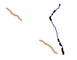
    The orange lines are from the map (the blue line at the right is a route I created on RWGPS so I could find the map). This image is from using GPXSee to view the map, which is a useful viewer program. There might be other OSM data in it but it doesn't always display. The map has no routing information. It enables on my 1030+.

    I'm not sure what the goal of this map is. Given what I can see, it doesn't seem like it's worth the effort of trying to get it to work.

    Long term, the best investment is to add the paths to the Openstreetmap database. There's some learning required to do this (so, it isn't exactly easy to do). My advice is to start out small (add a few things at first and avoid making "lots of changes").

    (By the way, that the Garmins let you use custom maps is a powerful benefit.)

  • Former Member
    0 Former Member over 3 years ago

    Do you know what type of encoding the file is using? (Unicode, ect...)  Are you able to share it?  Also does it even show up as a selectable map in your device navigation settings? If it lets you turn it on there but doesn't show up it is probably something to do with the layer number on the map hiding underneath another enabled map.

  • Former Member
    0 Former Member over 3 years ago

    One other thing. On the 830 I do have issues if I put a direct download from trailforks pro on to the device from the same state.  For example one is an overlay and the other is the full map and I do change the names but only one will show up in my list of maps on the device.  You might try temporarily removing all other custom maps to see if that has something to do with it.  I still don't know exactly what causes it but I think it's probably some type of title other than the file name is a duplicate

  • Ztbishop isn't reading the other posts in the thread and is talking about other issues that have nothing to do with your problem.

    What he's talking about:

    • The map you provided is using a default name and (probably) a default ID number. Having multiple maps with the same name and ID number might cause problems.
    • The text encoding can't be UTF-8. Some sources of OSM maps (like extract.bbbike.org) provide UTF-8 and non-UTF-8 maps (the UTF-8 maps do not work on the Garmins).
    • The map files have layers. An overlay map needs to be using a higher layer number so it gets drawn after the layers in the map it is overlaying (otherwise, you won't see the overlay information).

    =====================

    Bottom line:

    • It looks like the map you have has very little information (only two short paths). That's what is "weird" about it.
    • It doesn't seem useful at all (as far as I can tell).
    • You can use GPXSee (a Windows program) to view maps.
    • It would be better long term to just update OSM with the info it's missing.
    • Don't waste your time (or anybody else's) on this file.