This discussion has been locked.
You can no longer post new replies to this discussion. If you have a question you can start a new discussion

Does this navigation prompt make sense to you?

While navigating to a saved location I got this nonsense:

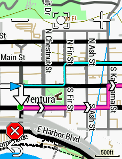
For some bizarre reason the 830 wants me to leave a street with a bike lane, go south 1 block to a busier street without a bike lane, ride for 4 blocks, then return to the original street. Who develops algorithms that do this kind of nonsense?

Of course I ignored the directions and was prompted to make a u-turn up until about 1/4 mile past where I merged with the track again. Not that it matters, but I'm using the ver 8.10 software.

  • Sounds about right.

    I'm in Sydney, Australia. There are plenty of roads where local councils have built cycleways to make it look as if they care about cycling when in fact they've been built where it's easy, not where they're needed.  OTOH, the popularity map data shows that where everyone actually rides is down another road altogether.

    So which should the algorithm choose? Personally, I'd want it to weigh in favour of where people ride, on the basis that that's probably the best/safest route.

  • Are you using the Garmin cycle map and is “popularity routing” activated? You can’t see the popular routing map/courses on the device itself, but you can take a look in GC, were you can enable a popularity routing heatmap (I think so). Perhaps that is a reason for your (strange) routing?

  • I do not have popularity routing selected. If I did then I would be even more baffled as the route Garmin selected is definitely less popular than the one I was on.

    The Garmin route leads to a road with much more car traffic than the road I was on. 

  • I don't know much about the meta-data stored alongside the location data, but I bet the map doesn't know there is a bike lane there. It also probably doesn't know that the other road has a lot of traffic. It would be neat if maps also knew things like average traffic density hour-by-hour, but that would be a tremendous amount of data, and it would probably make routing substantially more computationally expensive. The popularity routing seems like a good alternative, allowing the "wisdom of the crowd" to have filtered out bad roads already.

  • I have "Minimize Distance" as my "Calculation Method". I should hope that Garmin could figure out that the shortest distance is to continue straight and not go south 1 block just to go north one block after a short distance. The bike lane that I was riding in is on Open Street Maps so Garmin should know that it is there.

    Since Garmin ignores the"Minimize Distance" setting why would I believe that they respect the "Popularity" method of route calculation?

  • I can't see the entire route it proposed, but are you sure it isn't shorter by a very small distance?

  • I'm positive that it is longer. You can see that it's prompting for a right turn at my current location. Follow the pink line and you tell me if it is longer or shorter than just going straight.