
Hi all,
I did a ride yesterday in pretty grotty (i.e. very wet!) conditions, around Southern Scotland. I've had my suspicions about my Edge 830's ability to accurately record elevation data in recent rides (since 6.00?), but this was the first time that the data was absolutely, without question, completely and utterly garbage.
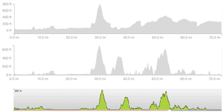
I've attached three plots here. The first is as recorded by the device (and seen in Strava). The second is Strava's "corrected" elevation plot and the third is taken from the original GPX used for the route, using plotaroute. It goes without saying that traces 2 and 3 look pretty accurate according to my legs following yesterday's ride and 1 looks almost like it would have been from a different ride altogether!
Any thoughts from anyone else here, or suggestions on how to correct this so that the device records more accurately?


