This discussion has been locked.
You can no longer post new replies to this discussion. If you have a question you can start a new discussion

Map Visibility settings

I had an issue yesterday where I found the map was not showing enough street detail.  I think this morning I found a setting to help this, but what I found is a lot of options under Map Visibility.    The manual only say "Allows you to set advanced map features".  Does anyone know where to find a better description of how these settings work?  Or is it just trial and error.

  • With trial and error i didn't see any changes. So if you find a manual about this settings it would be great.

  • Has anyone made the "map visibility" custom settings work?

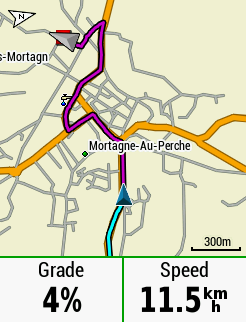
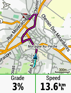
    I changed "Map Visibility" settings to custom and changed the "Zoom Level " for "Street Labels" & "Land Cover" from AUTO to OFF and nothing changed. I then changed the Zoom Level to the lowest setting of 5m, (according to forum comments this is the zoom level at & below when these map elements appear), and still no change. The maps still show Street Labels which clutter and obscure map elements, (the labels are on top of and obscure the roads),  and the Land Cover is a bit like a camouflage pattern making the map difficult to read especially at night.

    I do a lot of long distance and a lot at night and the street labels and land cover are not helpful. I have started to use some Garmin "On-Road"  format maps from BBBike.org and these provide a nice clean map BUT they are not routable!

    Has anyone had any success with activating the Map Visibility custom settings to achieve a nice non cluttered map or are these settings zombies left over from some previous golden age and now don't work?, Thanks


               "On-Road" Format                                         Standard Map (both before & after custom settings)