This discussion has been locked.
You can no longer post new replies to this discussion. If you have a question you can start a new discussion

Bridleways and footpaths

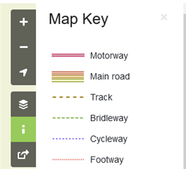
I have started cycling off-road in the English countryside in the past few weeks and am beginning to suspect that my Edge does not know the difference between a bridleway (where it’s lawful to cycle) and a footpath (where it isn’t). This such a basic distinction for a cyclist that I assume (and sincerely hope) that I am making some error in the settings.

Please tell me Garmin hasn’t released a cycling navigation product (or even whole range of them) which carefully plots routes it is illegal to cycle on?

  • Wongatta could you please let me know how to do the map build to strip tags and transplant it onto an 830?

    Also I'm wondering if I can have a map render (typ file maybe?) To make the footpaths/bridleways/cycleways coloured exactly like OpenCycleMap (red green and blue, respectively)

    Mainly because viewranger has ruined me

  • Download OSM data from http://download.geofabrik.de/.  You can download by continent, country, or smaller region.  Download the pbf file.

    Run osmconvert on your computer to convert the pbf file to a o5m file for faster processing.

    Run osmfilter to strip out tags/features you don’t want. Save results as a o5m file.

    See https://wiki.openstreetmap.org/wiki/Osmconvert and https://wiki.openstreetmap.org/wiki/Osmfilter for instructions and command line options.

    It might take a little while to work out the exact syntax of the command line to remove/keep just what you want.

    Get splitter and mkgmap from https://www.mkgmap.org.uk/

    Run splitter on your process o5m file to split it into smaller regions.  The feed the results from splitter into mkmap to convert into a Garmin map.  You can create a custom style to apply mkmap if you wish to.  Mkgmap can create a typ file and create a gmspsupp file with the typ file inside ready for copying onto your Garmin device.  mkgmap also creates map files ready for viewing in Basecamp.  Instructions for running splitter and mkgmap as well as how to create custom styles are on the mkgmap site.

  • You don't make a bespoke map.  You go out and survey the paths yourself.  If you find any that are incorrectly tagged in OSM you just edit the OSM data to correct it.  Anyone can edit the OSM data.  It is a crowdsourced map.  You can do this via the OSM website or via stand-alone programmes for editing OSM data.  Over time more and more paths will be correctly marked.  If you want to do only at home some councils put footpath/bridleway data on their websites but the according to the OSM rules you should really rely on what is actually visible on the ground.  Public Footpaths and Bridleways are marked by signs.

    Paths tagged as bridleways are marked on the maps on the OSM website.

  • Interesting. I seem to have been looking at the Open Cycle Map which I can't really make head or tail of. You are right - on Open Street Map, the bridleways are clearly marked. From a very cursory look, it seems that if it is marked as a bridleway then it is one in reality, but the reverse isn't true. There may be a problem with the track category. I know from local knowledge that some of the tracks are non-cyclable footpaths and others are cycleable bridleways but both are just listed as tracks. I may be wrong and will look into it further. Thank you.. 

  • That's the beauty of OpenStreetMap.  If you find errors you can fix them yourself.

    OpenCyleMap is just a different skin for OpenStreetMap.  It is all the same underlying data.

  • Hello again.  

    I'm really struggling - is there any way to have the Opencyclemap style (dotted red for for footpath, green for bridleway and blue for cycleway) on a map for the 830? On the garmin euro map they're just all black lines for "trail" 

    I tried TYP cycle files naively thinking they would display like OpenCycleMap but when I build a map with the wiki instructions for OSM with cycle style, it wont show up on my garmin

  • Thanks . Fantastic post. I wish the mods here could pin it somewhere.

  • You will have to create a custom typ file for the colour scheme you want.  Then you will have to use an application to apply it to your map file.  I think mkgmap can apply a typ file.  This can: https://www.javawa.nl/typchanger_en.html

    If you are creating a map from scratch you can do all this in one go (once you have set up the style rules).

    If you just want to create a typ file then https://www.pinns.co.uk/osm/typwiz6.html can do that.  You will need to know the codes for the various elements (types of lines, areas, etc).

    You can't edit the colour scheme on the Garmin maps.  I tried once and it didn't work.  The custom colours didn't show on my 830.  You will need to create your own or source them from elsewhere.

  • I've been returning to this thread periodically this year since buying an edge 830. Thanks to all who have contributed - very illuminating.

    I had an edge 800 with a GB ordnance survey (OS) map I bought on an SD card (at quite a lot of expense!) and found that worked fine for me. I just understand OS keys and that kept me off footpaths and on bridleways - I didn't necessarily use the unit to route me, I could just look at the map on screen and work out my own route. It saved me having to carry a paper map, or get one out of my pocket. Sadly the 800 became too unstable to use reliably.

    With the 830, I've tried various maps based and I just can't get on with them. Ultimately it's too hard to see the difference between bridleways and footpaths even on my Mac via Basecamp -  even if they have been correctly tagged - and when you are out on the trail, needing to find a legal route back to the car or home, forget it. And I appreciate the steps outlined above to both tag paths correctly for no biking (that bit I can cope with!) but the more fundamental part for me is getting footpaths and bridleways to show up in different colours on the map. Is wongataa's method of creating a custom typ file really the only way? I'm reasonably tech savvy but that is too much for me.

    I just can't believe there is no way to get an Ordnance Survey map onto a unit like the 830. I'd even be willing to pay again to do this - even though I already bought OS mapping for the old 800. Just seems like a backwards step...my only option seems to be to a) keep on tagging footpaths as no cycling in OpenStreetMap, which will at least help my on-device routing but b) to buy an Ordnance Survey maps subscription and view the maps on my phone when out on the trails when i want to find my own way home. Am I right or have I missed some way of getting Ordnance survey maps to show up on my 830??

  • but the more fundamental part for me is getting footpaths and bridleways to show up in different colours on the map. Is wongataa's method of creating a custom typ file really the only way?

    It is the only way. A custom typ file won't work with the Garmin maps.  I tried it to see what would happen.  You need to make your own maps or source them from non Garmin places.

    a) keep on tagging footpaths as no cycling in OpenStreetMap, which will at least help my on-device routing but

    Note that even if paths are marked as no cycling correctly in the maps the device will ignore this and can route you down them.  This is why I make my own maps and strip out all paths marked as no cycling so the device cannot route down them.

    You can get a typ file that mimics as much as possible the OS map style.

    Creating your own maps and custom colour scheme is a bit daunting at first.  With a good bit of trial error you can do it.  Once everything is set up running the tools is quick and easy.

    You can buy OS maps from Garmin that will work on your 830.  They are the TOPO Pro Great Britain maps and they aren't cheap.  You will need the download version.  They will be locked to your 830 and can't be transferred to another unit.