This discussion has been locked.
You can no longer post new replies to this discussion. If you have a question you can start a new discussion

Need assistance with understanding Navigation options from Device

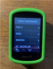
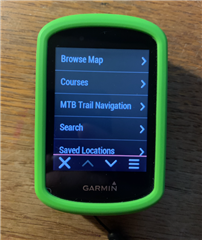
I'm trying to figure out how the MTB Trail Navigation option works on edge 830.  There are a bunch of pre-populated regions in there, but I have no idea how they got there - nor how to upload regions that I actually would use.

Does anyone have an idea on how this feature works?

  • Are you talking about Trailforks? There is no option to upload something. The actual Trailforks map needs to be provided by Garmin currently.

    So to recognize differences between what you can see on the web and on the 830 is usual.

    So if there is nothing in the Region you are interested in, but you find something on the web, you need to wait.

    Just you can create a track manually for every track you are interested in.

  • Yeah.  Depending on where you are Trailforks may have a lot or it may have very little.  I lived for a while where Trailforks had virtually nothing.   I used OSM and Strava heat maps to look for places to ride.   OSM shows just about every trail there is and Strava heat maps show where people ride.   Combining the two gave me a good idea of what's possible and what's popular.   You can then lay out a course in some app like RideWithGPS using OSMs, download it to your Edge, and then have it display on the Edge or have the Edge navigate it.  .