This discussion has been locked.
You can no longer post new replies to this discussion. If you have a question you can start a new discussion

Edge 820 / 830 / 1030 underestimate elevation (systematically)

Hi,

I have an Edge 820 but my friends have a 830 and a 1030, same problem for everyone.

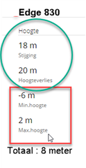
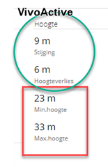
We have big gaps between our elevations compared to the real one given by strava or my suunto ambit 3 watch. Our high-end Garmins are all underestimating the elevation of the ride by around 20-30% which is A LOT!

We all set the Garmin Edges to 1s recording to make sure the GPS is recording with the best accuracy but it does not change anything.

I had a look at the professional riders on Strava and when they end a race (the same one of course) those using a Garmin Edge have a VERY underestimated elevation (around -50%!).

Example:

Thibaut Pinot is using a Garmin Edge 1030 on this race: https://www.strava.com/activities/2441786636 His elevation is 864m.

Laurens ten Dam is using a Garmin 820 on the same race and gets 850m https://www.strava.com/activities/2441722380

The real elevation of this race is 1795m... https://www.francebleu.fr/sports/cyclisme/criterium-du-dauphine-2019-3e-etape-le-puy-en-velay-riom-1558354625

There is obsiously something wrong with Garmin Edge and elevation at the moment.

Please take a look at this issue. My Suunto watch is not supposed to perform better than a premium Garmin GPS, and yet it is.

  • even with the latest FW 6.20? It used to be accurate for me before the upgrade, not anymore after.

  •  Maybe that's not an absolute source of truth but I compared my data to the elevation indicated on IGN topo maps, and I can assure that they are really accurate. It seemed to me that 50 mt of discrepancy in a total gain of 950 mt might not be so accurate. What I mean is that my Garmin marked the correct elevation either on start and on arrival, but it's the elevation gain that was wrongly calculated. Maybe is some kind of algorithm that Gaston be adjusted. 

    Thanks for the reply

  •  

    i've got FW6.20 . It is much better. At least it has correct up and bottom elevation on track.

    But it does not respond to small ellevation changes like small hills or small descends ~5 meters. Garmin pretends as if there is no gradient ((

  • The instantaneous gradient is never going to be particularly reliable.  Think about what you are asking the device to do: calculate the rate of change of something that is changing very slowly with intermittent sampling of noisy data.  If you have any calculus (or discrete math) you'll see that this is a difficult/impossible problem.   I don't know for sure, but I suspect that the device is drawing a line through some number of previous barometric elevation measurements with a least-squares approximation.  But some of that data might be noisy and (in any case) only reflects info prior to "now" -- it can't predict what the next elevation reading will be, so it is likely that the reading you see "now" is not going to predict what you see in front of you.

    It's possible that the elevation data is supplemented with some segment/route elevation data, but if you check the gradient values on a Strava segment you will see that they fluctuate wildly.   Even the Climb data (derived from Strava Route) shows crazy gradient changes.

    I don't think that the elevation *gain* is computed using the gradient values at all, and I think that over a reasonably significant climb the total elevation is pretty accurate.  I think the small fluctuations are filtered out by the Garmin algorithm, though I don't know what their thresholds or methods are.

    For gradient, I tend to use my eyes and my legs which are the best judge of "how frigging steep is is this bit I'm on now".  I don't need a computer to tell me that.

  • you'll see that this is a difficult/impossible problem

    It was not a problem. It used to be Ok

  • @garmin-matthew

    FW 6.22 - skipped the elevation issue. Elevation is still not perfect. Other devices gives better data when recorded side by side. 

  •    
    The elavation shown on the VivoActive HR looks good to me. (this is more likely what is has to be..) So why is the Edge so much more??
    In the Edge Min.Height and Max. Height looks alo correct... (red part)... Vivoactive has calibration problem?

  • Same things as ever... Garmin, let’s do one thing: Please pay me the double I receive on my company and I will end all of this stupid mistakes. It’s that hard to have a decent test framework and only deploy when it’s fully validated by the product owner?During this year you already had a lesson to learn with the ransomware situation. But it seems that you only learn the hard way...

    Me, I just nade my decision of selling my all Garmin products.

  • My 830 tracks with Strava very well.  My ride today: 49 miles and 2,231' of elevation gain.  Strava has 2,201' of gain.  One thing I did notice is that the unit tracks elevation more accurately when it's perfectly level to the ground.  When I had the unit slightly tilted up I get 5% less elevation gain.

  • Today's ride: 52 miles and 2,808' of gain.  Strava shows 2,814' of gain.  Running FW 6.22 and with the 830 perfectly horizontal to the ground.  Temp. of around 55F all day.  I do notice that on very hot days the elevation is underestimated.  So the elevation problem could be correlated to the ambient temp.  just an FYI.