This discussion has been locked.
You can no longer post new replies to this discussion. If you have a question you can start a new discussion

Edge 820 / 830 / 1030 underestimate elevation (systematically)

Hi,

I have an Edge 820 but my friends have a 830 and a 1030, same problem for everyone.

We have big gaps between our elevations compared to the real one given by strava or my suunto ambit 3 watch. Our high-end Garmins are all underestimating the elevation of the ride by around 20-30% which is A LOT!

We all set the Garmin Edges to 1s recording to make sure the GPS is recording with the best accuracy but it does not change anything.

I had a look at the professional riders on Strava and when they end a race (the same one of course) those using a Garmin Edge have a VERY underestimated elevation (around -50%!).

Example:

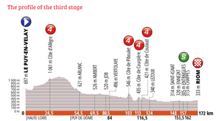
Thibaut Pinot is using a Garmin Edge 1030 on this race: https://www.strava.com/activities/2441786636 His elevation is 864m.

Laurens ten Dam is using a Garmin 820 on the same race and gets 850m https://www.strava.com/activities/2441722380

The real elevation of this race is 1795m... https://www.francebleu.fr/sports/cyclisme/criterium-du-dauphine-2019-3e-etape-le-puy-en-velay-riom-1558354625

There is obsiously something wrong with Garmin Edge and elevation at the moment.

Please take a look at this issue. My Suunto watch is not supposed to perform better than a premium Garmin GPS, and yet it is.

  • Looking at the profile something around 850 looks about right. 1795 does match the profile.

  • I compare the elevation of my 830 to Strava on almost all rides and I find the 830 to be extremely accurate, within 5%.  My friend who has a Wahoo Bolt and his unit is severely over the real elevation gain.  Yesterday we did a 71mi. ride together and his unit gave a 38% higher elevation gain than my 830!  I had thought my 830 was way off but Strava confirmed that my elevation is the correct one.

  • Strava data is generally bogus and always has been, it often over-inflates the altitude gain wildly as it bases it on topographic data of nearby locations (which may be the top of a hill or bottom of valley, but not where you are actually riding). They have tried to fix some of that lately by using data from rides done with barometric devices, but it should still be taken very much with a grain of salt.

  • Didn't know that.  So is there a better way to verify if the 830 is spot on or my friend's Bolt that shows 38% higher elevation gain?  It's worth noting that my 830 and Strava varies by less than 5%.  So unless the 830 is way off I don't think Strava is that bad.

  • GPS Elevation data isn't that accurate.  Barometric elevation data can be massively affected by the weather.  If the weather is stable the the barometric elevation data is likely more accurate.  The only way to be sure which is closer is to verify what the actual elevation changes were using accurate survey data (which you likely won't have access to) or the next best thing by estimating it using large scale maps with contour lines from your countries national mapping agencies.

    Strava elevation data is taken from freely available terrain data created from Space Shuttle missions.  This data can have artifacts such as holes where clouds obscured the clouds and ground features such as buildings and trees can skew the elevation of the ground.  The resolution available also varies depending on the part of the planet so in some places the elevation data is dodgy for fine detail due to low resolution.  Starva say they try and refine the source data using data recorded from people's rides uploaded to Strava.  How much that helps we don't know.

    In short Strava elevation data can be good or bad but you can't really know.  At least it will be consistent.  In general I disregard elevation stats because I know it can't always be trusted.  I am just happy if my Edge reports similar elevation gain and loss numbers for a loop ride.

  • I’ve never heard of Strava elevation data being derived from space missions, where did you get that from?

    Previously it was topo map data, now they calculate based on averages generated by the community and it ‘IS’ more accurate now, but still not perfect.

    i do a regular loop, Garmin always has it at around 540m gained give or take. If I used Strava elevation correction that jumps to 850m or so. If you have ever heard of the Norton Summit climb here in Adelaide, it’s 5.6km of fairly constant 5% gradient. Elevation correction used to show downhill sections in the middle of it, I wish!!!

    Details here 

    support.strava.com/.../216919447-Elevation-for-Your-Activity

  • The previous topo map data you mention was captured during Shuttle missions (the Shuttle Radar Topography Mission) scanning the planet's surface.  It is freely available to download yourself should you wish to and is the only freely available elevation dataset covering most of the planet.

  • Some weeks ago found out a massive elevation inaccuracy. My Edge 830 gives me about 30%-40% less the regular elevation it used to be on the same track, same device, same weather. I do calibrate every single time. But when you climb 10% - 15% and garmin gives 0% or sometimes negative grade, that is not about calibration.

  • Total time and distance is exactly the same, but elevation is much different

    used to be (ok)
    https://connect.garmin.com/modern/activity/5037261040

    Now (not ok)
    https://connect.garmin.com/modern/activity/5342671731

  • Support does not respond. What should we do?