This discussion has been locked.
You can no longer post new replies to this discussion. If you have a question you can start a new discussion

Garmin Connect:- Courses

What has happened to "Courses" in Garmin Connect, they were not much good for route creating, but now they have got worse. I only use the program to add elevation data from a course created in Garmin Mapsource and a speed for the VP, but today when I try it, the program has been modified and it is a shambles.

1. When you import a course, the map sometimes stays on Ilinois USA, you have to scroll across the World to find the course unless you save it and then reopen it.

2. There is now no list of all Course points that have been built into the course, they only show up on the map.

3. The speed calculator only works if you input a time, try inserting a speed and all you can do is input the first figure, ie, if I want to input 20, soon as I press the "2" button, all I get is "2.0" and a ridiculous ride time and cannot input anything else. So it is guesswork by inputting times to get the speed you want to ride at.

4. When you open a course to go to edit it, it just comes up "Page not Found" "Sorry but the page you want no longer exists"  but eventually I discovered if you sit and wait, the course pops up.

5. Locate a position on the default map, and want to have a closer look using the Satellite map to see if a course point is in the right position, and it jumps to the start of the course, how infuriating as you now have to find that position again

What other changes have happened I have yet to find
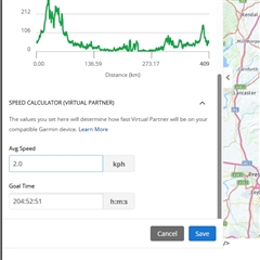
  
This seems to be a Garmin trend, try and improve something and it is made worse

  • I've always considered myself pretty savvy at figuring out computer programs, but GC has always seemed impossible to create courses on for myself.  It's just never been intuitive for me.  I create on RWGPS (intuitive, works great), then transfer to GC just to get it stored on my GC account and hoping that puts it in the most agreeable format for my Edge devices.  I don't concern myself with anything more advanced like course points and setting speed.  I just want a line to follow through the woods on unfamiliar trails (mtb).

  • I have noticed items 3, 4 & 5 too. The workaround for item 3 is to copy and paste a value from some other source. I get Kansas City for item 1. Not sure about item 2 as I haven't used it much.

  • Just had a play around and discovered by accident that if you try to set a speed for the VP, you can increase it in implements of "0.1" by pressing any numerical button from 5 - 9. But it is very slow and no way to go back if you overshoot the desired speed. That alone confirms it has been broken. Thankfully I don't have to rely on this program for route making, it has to be the worst on the whole internet and not a good advert for Garmin that is supposed to be into navigation products.

    As for Komoot, I cannot see anything good about it, I have used it  before and passed it by as not worth bothering with. I can have a course made in Garmin Mapsource, with course points etc built in and loaded onto the Edge well before the time it takes to make a course in Komoot. At least with Garmin Mapsource, it is on my own PC, very fast with not having to wait for maps to load etc, and I am planning on the same maps that I have on the Edge so its 100% compatible. Why Garmin brought out Basecamp to replace Mapsource many years ago, I don't know, because it is absolute rubbish to and not worth bothering with.

    The only reason I use Connect is to just get the elevation data.

  • Item 3 Speed: Same problem but work around is to click in the speed box and use the Left Arrow key on your keyboard to add additional numbers, So to add 15.0 as virtual speed enter 1 this gives you 1.0 then left arrow key to the right of the 1 and add 5. Should wind up with 15.0. 

  • Its a workaround but that is all, the whole system has to be messed up to have to do it that way, especially when Garmin themselves have not gave instructions on how to do it.

    It works as well if you just type the first number in then move the mouse cursor to just after that number, click and type the next number in.

  • Just bumping this up, but I also noticed that their is something wrong with importing GPX files into Garmin Connect Courses that have "Course Points" in. I noticed this about 3 weeks ago when I did an event and the course points did not show up correctly but wanted to confirm it, their is no navigational data ie distance and time too showing on the course points data page and some times they do not show up at all. One thing I did notice was when I pressed "Start" on the Edge, and before I started riding, the last three course points flashed up one after another as if I was there at them, and I was just left with the "Finish" left on the Course points data page.

    I did an experiment a couple of days ago, added some course points to a GPX file, imported it into Garmin Connect, added some more course points and then uploaded to the Edge. When I opened the GPX in the Edge, only the course points created in Edge had any information, all the others showed up but with no details. I also tried it with a GPX I did from Ride With GPX, it was the same result

    I know this has worked perfect importing GPX files from Garmin mapsource into Garmin Connect and this is a recent issue that has happened.

    Also another change, just up to recent, I could add a Course point into a GPX in Garmin Connect and it would show up immediately and I could type in its name straight away and add what type of Course point it is etc, but now, their is a 30 second time delay were the screen goes blank before the map opens up again. This never used happen, it was instantaneous. A couple of days ago I was adding 16 course points into a forth coming 400 K randonnee, 8 minutes I wasted sat looking at a blank screen.

    Also, in Garmin Connect when you import a GPX into it, the elevation changes by a lot that is very noticiable. I import an official GPX for a Randonee with the correct elevation details for scoring "altitude points" into Garmin Connect, the altitude can be reduced dramatically by up to a 1000 metres, then when I import it into the Edge, it is completely different again but increased from what was in Garmin Connect and also different but slightly less than the original. It seems Garmin do not have compatibilty between its own course creator and the Garmin maps we have on the Edge. But, I have not had much time to fully explore this issue yet.

  • I think there are other problems with GC GPX files as well. I don’t usually use GPX files, but a few days ago I experimented by creating a short test route in RWGPS, importing it into GC and exporting it again.

    The RWGPS version loaded correctly but the GC one did not, only showing a line connecting the start to finish. The GC version added time stamps for each individual trackpoint that were not present in the RWGPS version. To test, I manually removed those timestamps and then it loaded correctly.

    So, it seems there is an issue with GPX files exported from GC due to trackpoint timestamps.

    Update: I dug a little deeper and the issue looks to be the that the time interval between timestamps is really small ie 1.2 sec covering an 850m course. Manually increasing the interval between stamps allowed the GC file to load correctly.