
I have a question about upcoming climbs. I import the same gpx file to Garmin Connect and Ride with GPS. When I sycned my Edge 530 I got 2 completely different information about upcoming climbs.
Does anybody knows where is the problem?
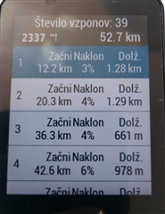
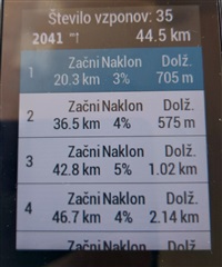
I have a question about upcoming climbs. I import the same gpx file to Garmin Connect and Ride with GPS. When I sycned my Edge 530 I got 2 completely different information about upcoming climbs.
Does anybody knows where is the problem?
