This discussion has been locked.
You can no longer post new replies to this discussion. If you have a question you can start a new discussion

Navigation map

On the navigation map that pops up when you approach a turning, how do you alter the two data fields at the bottom, ie Direction and time to go before the turn, I have searched every where and cannot find the settings unless it is well hidden. Both of them I have no use for, ie, I do not need to know if I'm heading South or North etc or the time given is pointless, when the map pops up and says I turn in 30 seconds, I know I am going to turn in that time, but that time is changeable as I may slow down, but more importantly, I have no way of knowing how far down a road to look that could be 30 seconds away to look for a junction, especially in a town.

Preferably, I would rather see "Distance to Next" as then, I know to look about 100 yards down the road for my turning and plan my speed etc to make the turn and speed etc will not affect that distance unlike time can be.

Also, can the distance that the navigation window pops up be changed, ie, mine pops up every time at 0.3 of a mile and stays on which is too far away, all it does is obscure the data fields I want especially when I am pacing a fast ride and is a nuisance as I then have to get rid of the navigation map by pressing the buttons and breaks the rythmn of the pace.

  • Yes - it would be such a perfect world if Garmin would allows us to have a 'Pro' mode - the device to  have turn guidance on the plotted route - irrespective of the map  vs route issues. But that wish could be unrealistic as i do not understand the algorightm of the route mapping properly to wish for such a function.

  • Not my device or map but the originator of the screen shot says the device is an 830 and the map is a Garmin Topo France series. Members of my club try to minimise the problem of the Garmin calculating a different route to the original route by always plotting the route with an OSM map overlay so that the original track and the Garmin's map "should be the same" but even still there is frequently "problems", On the second or third night of a 4 day/night 1200 km ride (having only had 4 hours sleep) you just don't want problems with the route as my brain (at least) does not function too well under these conditions. Following the map line, using "off course" warnings and maybe a few custom course points and a TCX route is better than always fearing the Garmin is going to send you down the wrong road in the middle of the night.

  • It mirrors my experiences, for years now, I only use a route planner on my PC to create my courses and routes along with planning them on the same maps that I have on installed on my Garmin devices just so that I get 100% compatability. Also likewise, any event that I do, I always trace over the organisers track to create my own route

    The program that I use is Garmin Mapsource, Garmin Basecamp is a load of rubbish and far too complex and to much messing about to use, I'm surprised its still on the go.

    But despite that, once installed onto the device, it can still change it and you never know till it happens if your lucky to spot it.

  • These custom course points - can you please elaborate ? how do they work for you and how do i implement them into the 530. 

  • You create them in the route planner when planning a route.  They are a location where some text pops up on the screen of your Edge.  They can be used for navigation prompts or anything else you want.  They are called cues in RideWithGPS and are listed in the cuesheet.  Other route planners may call them something slightly different.

    You need to export the route from the route planner as a TCX or FIT file to have the course points saved in the route file.  Put the route on your Edge as normal.

    As long as course points are turned on in the settings for the route in question (which they are by default) when you reach the location of the course point whatever text you specified for that point will be displayed on your Edge.

  • So, the image is a case of using a different map. 

    but even still there is frequently "problems"

    There can be an issue with the devices picking a brief shortcut. This issue happens more frequently if there are two ways very close to each other (like a cycle path next to a road.

    Following the map line, using "off course" warnings and maybe a few custom course points and a TCX route is better than always fearing the Garmin is going to send you down the wrong road in the middle of the night.

    If navigation is critical, you need to be looking at the map anyway.

    The calculated route is generally going to be close to the loaded track. So, the road isn't going to be that wrong.

  • useful discussions - i will create a profile purely for navigation on the plotted path (Recalculate disabled, Turn Guidance Off).

    Where exactly does the custom cues pop up in the 530 - is there a field in the 530 i have to enable for the custom cue to pop up ?   

  • If you have Course Points as part of your route (as per Wongataa's post above) you will see 4 things.

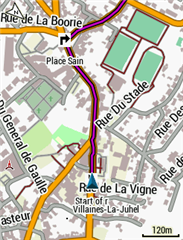
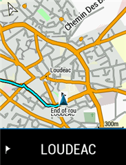
    1. The Course Point symbol shows on the map screen at the appropriate point, a left or right or straight ahead arrow or other depending on the Cue / Point Type assigned by the mapping software or the user. (below a Right turn point just outside Villaines-La-Juhel), note there is also a 10 character "Point Name" in this case "Place Sain" which is an abbreviation of "Place Saint Georges" which is the name of the street into which the right turn is made

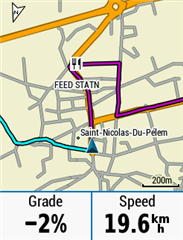
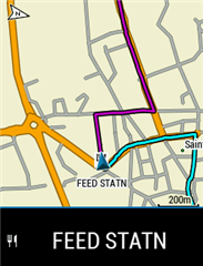
    Re the comment of @leginswal regarding "mandatory routes passing through checkpoints, and to enforce you are on the route, secret checkpoints", the right hand screenshot was one of those "secret controls", nominally just a "Feed Station" but actually a secret control there you had to checkin, if the Garmin had taken a short cut and you missed the control you would be disqualified.


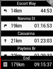
    2. There is a screen that appears in the enabled screen series that lists the Course Points (Point Name, Current Distance to the point, the Point Type ie L, R, Other), the list shows the next 3 or 4 points and the last and the list can be scrolled to see others. The list also shows an estimated time to the point but this might not be accurate, it is sometimes unclear what speed the Garmin uses to estimate this.

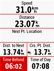
    3. There is a data field available for inclusion on data screens called "Course Point Distance" (Crs. Pt. Dist.) which shows the current distance to the point and the Type Symbol,

    4. When you reach the point you get a bottom of screen notice with the Point Name (10 characters) and the type symbol. Note that the notice only appears as you ride over that point (give or take the GPS accuracy), some course planners allow you to move the Course Point a nominated distance (say 30 or 50m) so that you get the notice before the point, the notice includes the tone which is often difficult to hear


    Most Route Planning software will generate course points for turns and may allow other custom points to be added. There is a Garmin limit on the number of points that can be in a route, 200 I think.

    Note that I don't always use the planner generated cues for every turn as the zoomed in map screen shows the turns well enough and even a zoomed in map shows a couple of kms ahead, more if zoomed out a bit, I might insert course points for some towns to break up a stage into smaller bits and the end point of a stage or the first of a series of turns I have to pay attention to.

    Hope that helps.

  • So, the image is a case of using a different map

    Yes but still a Garmin supplied map (noted as being 530/830 compatible) and still based on OSM

  • It doesn't matter that both came from Garmin.

    It's the map data that matters and the data used to create the track is clearly different from the data being displayed on the map screen.

    OSM data changes (gets updated), which means OSM maps using data from different times can be different.