This discussion has been locked.
You can no longer post new replies to this discussion. If you have a question you can start a new discussion

Navigation map

On the navigation map that pops up when you approach a turning, how do you alter the two data fields at the bottom, ie Direction and time to go before the turn, I have searched every where and cannot find the settings unless it is well hidden. Both of them I have no use for, ie, I do not need to know if I'm heading South or North etc or the time given is pointless, when the map pops up and says I turn in 30 seconds, I know I am going to turn in that time, but that time is changeable as I may slow down, but more importantly, I have no way of knowing how far down a road to look that could be 30 seconds away to look for a junction, especially in a town.

Preferably, I would rather see "Distance to Next" as then, I know to look about 100 yards down the road for my turning and plan my speed etc to make the turn and speed etc will not affect that distance unlike time can be.

Also, can the distance that the navigation window pops up be changed, ie, mine pops up every time at 0.3 of a mile and stays on which is too far away, all it does is obscure the data fields I want especially when I am pacing a fast ride and is a nuisance as I then have to get rid of the navigation map by pressing the buttons and breaks the rythmn of the pace.

  • I don't think you can change them.

  • You can change the turn pop-up to text only, but I don't think you can change what is displayed.

    When it comes to how long ahead the map pops up, this is a tricky issue. If it was set at 100 yards, when you are going fast on a steep downhill, this is only a few seconds warning. But if you were going up the same hill, 100 yards be more than 2 minutes away. No one setting will cover all situations perfectly, but I think that time based is probably the most broadly applicable way of doing it, and giving you enough time to set up for a turn.

    Note that the distance to the turn (and direction and shape of the turn) is actually displayed at the top of the map page.

  • I found out today that the distance can be changed. Usually I have the Garmin set to "Automobile Driving" in the settings, but today, I changed a few things to experiment and I found that if the Garmin is set to "Cycling" then the distance of the navigation map pop up is reduced to 0.1 miles which is far better. So "Automobile" mode must be 0.3 miles for the pop up.

    The unfortunate drawback though was, the Garmin had changed my course at one point I presume to be more cycling friendly but I ignored it. This is why I always select "Automobile" as this does not happen having your course changed to cycle paths and tracks etc.

  • The unfortunate drawback though was, the Garmin had changed my course at one point I presume to be more cycling friendly but I ignored it. This is why I always select "Automobile" as this does not happen having your course changed to cycle paths and tracks etc.

    Setting Recalculation to Off or Prompted is probably a better cure for this than Automobile. 

  • You suggested setting "Recalculation" to off in a previous posting I made a few weeks back and I informed you that it is "Off".  You also suggested "Turn Guidance" does not create the problem of routes being changed, but I have found that it does before you mention that as well.

  • Turn Guidance is not related to the unit changing the route - you think it does but it doesn't. Play with the settings and go for a ride to test and you'll discover it for yourself. This has been discussed - pro tip - set the Recalculate to OFF for 99% of rides unless u want the unit to be creative with how you reach your destination.....in mid ride with the recalculation enabled when something triggers the recalculate function (like u veered away from the route a bit or it loses GPS) it'll delete your original route and create a new route for you....it won't dynamically return you to your original loaded route - that one has been deleted (gone forever - till you manually load it back). The unit does not dynamically recalculate like the Nuvi Garmin GPS car units. It will recalculate ONCE (one time) and will not auto correct as you ride - you'll have to ride the route it created- so if it recalculates a route that you have to go up mt everest 3 times to get home, that's your ride. The only way to correct it is to force it to recalculate by loading your destination again as u get closer to your destination - if the route has only 1 option left to your destination then you're lucky it'll choose that route. otherwise it'll go left, right, whichever way it pleases....again it does it once and load the route for you - it won't auto correct itself later . Mt everest here i come.

    Use Recalculate to Off/ disabled - your original loaded / planned route will be preserved in the unit.

  • Turn Guidance is not related to the unit changing the route - you think it does but it doesn't.

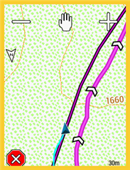
    It can and does. In this example the user has loaded a course (the darker red line) and selects ride (initiating the initial "calculation" ie not "recalculation") but due to some issue with the map data the garmin has replotted a different calculated turn guidance course along a parallel track / road (pink line), as you can see the rider is following the original course. This happens frequently enough for me to not use "turn guidance" as my club rides are mandatory routes. Mostly happens when the turn guidance calculation can not make a connection between consecutive track points so plots a different route, frequently occurs if your route goes between bike paths and road ways leaving some small gap that the calculation cannot bridge.

  • Ah...understand you now - what you plotted may not be agreeable with the map garmin uses so it does fall back to the map data....not your plotted route. I've got that issue sometimes....crossing over embankments, mixing pedestrian path with proper paths etc. When plotting using RWGPS u can't tell where there'll be an anomally because it's not the same map the Garmin is using. I'll then have a WTF Garmin moment and realise it's due to the difference between my plotted route and the garmin map. So if you're in a new area you'll want to look carefully at what's on the map - they are things like 'kissing gates', barriers that the garmin map may think it's a no-go and it will create a reroute around it then. Would be nice if Garmin can have an additional 'Pro' mode for us experience users where it'll literally follow our plotted route.....even if it means going off a cliff. But i'm kind of used to not expecting good new things from Garmin anymore....makes life sweeter. 

    i can't have Turn Guidance off - then how do u know how far your next turn is - constantly looking at the map page ? With Turn Guidance - if it says my next turn is 4.5km then i can chill and watch the pretty girls go by while cycling along the route till it get near to that 4.5km turn point. where it'll then tell me to make my turn.

  • What is the track line following?

    I don't think there are two paths/roads on the Garmin map here.

    I'm guessing the track was created using a very different map.

    That is, what we are seeing here is one road/path that happens to be placed in different locations on the two maps.

    Given that the recorded line is following the track, if it's the same path/road, its placement on the Garmin map (OSM) appears to be a bit incorrect.

    The routing can have issues with roads/paths that are close together but that doesn't seem to be the case here.

    You really should provide the place/location where this is happening. 

  • "Turn Guidance is not related to the unit changing the route"

    Sadly it is. It often happens regardless of how the route was created. I do a lot of long distance endurance events on mandatory routes passing through checkpoints, and to enforce you are on the route, secret checkpoints. The 530 is not trustworthy to stick to the loaded route without making a change so it is essential that "Turn Guidance is turned off along with "Recalcualte" turned off which I always have, which if you had read my earlier posting you would have seen that I mention that I do instead pf posting to turn it off.

    When on a known route and a change is made, you can spot it and ignore it, but on unknown routes, any deviation is not  spotted so easily and you have to trust the 530 and it can result in missing a checkpoint.

    About a couple of months ago, I rode an event, "Recalculate" off as normal and I was trying out the "Turn Guidance", I came to a major cross roads where I know from the past that I turn left, the 530 wanted me to turn right, I ignored it.

    Recently, I have been doing the same circuits getting ready for a 1400K ride, virtually every time, I get a deviation from the route on the 530. And if I get a fast time, I delete the old saved course, and create a new route from the ridden ride. But it makes no difference, the "Turn Guidance" at some point can change the route despite the fact the route was created from a ridden ride.

    The only way to get the 530 to follow a route correctly is to turn off the "Turn Guidance" along with the "Recalculate".

    The Edge 800 was the same and I vowed to never buy another Edge product, umpteen years later, I thought things may have improved with several Edge products released in between, and what do I find, nothing has changed. They cannot even do a simple time and distance calculation as I have also found, which the 800 also could not do.

    It is no wonder, most riders doing endurance events use the Garmin Etrex range as they are more reliable for navigation.