This discussion has been locked.
You can no longer post new replies to this discussion. If you have a question you can start a new discussion

Very bad elevation accuracy

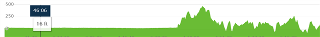
My Edge 530 got quite dirty in one of the last rides and is now having issues with the elevation measurement. The ride was recorded with more than 100m in heigt gain, the reality is maybe 1/3 of that. Also the start point is about 50m to low, the end point almost 75m to high.

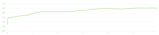
Riding in the other direction, the start point (end of track above) is 130m lower, the end point (start of track above) more than 100m heigher´. I did manually set the elevation of the device several times, but each new route starts with a very wrong elevation and only gets worse over time.

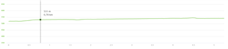
My wife did ride with me, also using a Edge 530 and her elevation profile is much closer to the real world and is also missing the big jumps.

Is this an issue of the device that can be fixed somehow or is something broken?

  • PS: both devices run on the 8.20 software.

  • I have the same problem. It seems this issue happens because the altimeter is not working properly due climate conditions. Maybe it was raining or some liquid fall on the Edge? I will buy a cover for the Edge and a screen protector. 

  • I had exactly the same issue last weekend during a race.  At one of the aid stations, I spilled a few drops of nutrition on the Edge and rinsed it off with water.  The rest of the ride, the Edge recorded over 3000 feet of elevation, whereas the corrected elevation (confirmed by my FR945) was 138 ft.

    You can see below where this happened.  The whole graph should have looked like the first half.  I haven't tried it yet, but hope it is fixed after I rinsed it at home.