This discussion has been locked.
You can no longer post new replies to this discussion. If you have a question you can start a new discussion

ClimbPro is not really working well

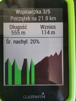
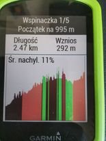
Hi, i have bought my Garmin Edge 530 in October and since April there have been some problems. I dont know why but ClimbPro is acting like broken. I created quite a lot of courses with some climbsbut these climbs on ClimbPro doesnt look like irl. Here are some photos. Sorry for my English I'm still learning the languageSweat smile


  • What did you use to create the courses?  ClimbPro just uses the elevation data in the course file so these graphs are down to the tool used to create the course, not your Edge unit.

  • Of course I used Garmin Connect.

  • I also have the same problem on my edge 1030. Everything I create a route in Garmin Connect on mobile device (Android) and send to device. On any given route I have the approximately the same results:

    • What GC tells me overall elevation will be: 1000m
    • What Edge tells me remaining elevation at start of ride: ~3000m
    • What the route actually ends up being after completion: 1200m

    And similarly every time I hit a climb using ClimbPro, the elevation remaining Vs actual elevation gain is around 3:1

    Like OP shows in their screenshots above, each ClimbPro climb looks like a sawtooth.

  • How recently did you create those maps in GC? They did make changes towards the end of April that were meant to improve the elevation data, but you need to make small change to your route so that the data gets regenerated.

    Try changing one of your route and sending to the Edge again see if the elevation data is better

  • Done this several times over the last couple of months. It really screwed up a long (170km) ride I did. But I've also created a ride earlier this week and rode it this morning and similar issues. Haven't fully tested but seems to be bigger discrepancy when creating on GC android then editing on GC Web before sending to device. Will test some more, but it's frustrating cos it makes the use of elevation data during the ride meaningless

  • Fully understand. The feature is only as good as the data it has to work worth.

  • Try using a different route creation service to see if you are happier with the elevation data.

  • There aren't many sources for the elevation data (it's mostly from SRTM).

    Strava, apparently, can use elevation from rides recorded by other people.

    Historically, the elevation for bridges was the water level.

    Ridewithgps gets the elevation of some bridges correctly but not all of them.

    I don't believe the SRTM data includes correct elevation for bridges (but it might). So, it's possible that some sources are augmenting the base DEM data.

    • What GC tells me overall elevation will be: 1000m
    • What Edge tells me remaining elevation at start of ride: ~3000m
    • What the route actually ends up being after completion: 1200m

    Aweatherall pointed to an old (now solved) issue with the elevation from the course.

    (It's not "elevation". It's "elevation gain" or just "gain".)

    So, the 3000m is explained (and wrong).

    For the other two, it's common that the device measures a larger elevation gain than the planners estimate.

    This is mostly due to the measurement being more sensitive to smaller changes.

    In any case, the gain is an estimate. The difference between 1000 and 1200 is pretty close.

    It will tend to be better for larger gains over shorter distances.