
Hi there,
I purchased a brand new Garmin 530 (updated and paired etc etc) before taking it out for my first ride today on a 100km out and back route. When I got back I realised that the elevation drift towards the 2nd half of the ride (~40-50km onwards) was really bad. Going out up till 40km or so the elevation matches pretty well with 'corrected' elevation from garmin connect and training peaks but the second half of the ride the unit was off.
I would expect the profile going out to be a mirror image coming back given we are going out and back. My riding buddy had another 530 and his one shows a mirror image profile for the ride elevation,
Note that it was a typical warm and cloudy day throughout the whole ride here in Malaysia with no rain so dont think there was any issue with water in the barometric sensor. I've also mounted my unit on the stem (but dont think the mounting would be an issue given that it recorded ok-ish elevation figures until ~40km)
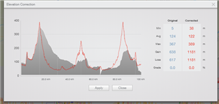
My concern can be seen in the chart below grey is the recorded elevation and red is 'corrected' elevation.
Is this a software issue that can be fixed? I've included my garmin connect activity link as below:
https://connect.garmin.com/modern/activity/5944295802
Must say this is a bit worrying given its the 1st use of a brand new garmin as I would have expected the profiles to be similar.... Not after absolutely correct elevation numbers but it should've been in the ballpark and not way off on the way back...
Does anyone else have this problem also>