This discussion has been locked.
You can no longer post new replies to this discussion. If you have a question you can start a new discussion

Total ascent under calculated during all rides. Noticed elevation field DECREASING during recent 6 minute / 300 ft climb

My Garmin 530 has been under reporting total ascent for a few months.  This is comparing ascent data to my old Garmin 500, my riding partners Garmin 500, Garmin Connect elevation correct, Strava elevation correct, and 15 years of riding these same hills.  The Garmin 530 under reports total ascent compared to all of these benchmarks by anywhere from 20 to 50% on every ride. 

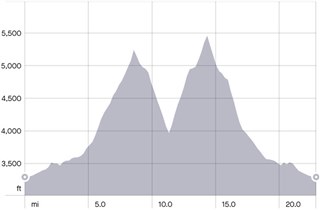
So I started paying attention to the total ascent and elevation fields during sustained climbs.  On my most recent ride, during a ~300 ft climb the elevation field decreased from 5,473 to 5,425 ft and the total ascent field increased by 1 foot.  I have noticed this same phenomenon on other days so I don't think it is a weather phenomenon. Looking at the Garmin Connect activity profile, that same section of road that is a steep ~6 minute climb shows a similar decreasing elevation.  The Garmin 530 reported a total ascent of 2,369 ft of climbing.  The correct total ascent for the activity was over 4,000 ft (there were numerous other climbs that the 530 under counted).

I would really like to have accurate total ascent data during my ride and not have to wait until after the ride to "correct" the data.  Any help would be appreciated.

The Garmin was running version 5.10 and more recently 5.35 (I think?)  It is now updated to 5.50 but I have not ridden with 5.50 yet.

  • I noticed this for the first time a few days ago after updating to b5.51. I never really pay attention to elevation but was changing screens and noticed my elevation was decreasing on a climb. I actually forgot about it until you mentioned it. Subscribing to this thread to see where this goes. 

  • Sounds like a faulty sensor or something blocking the port. I would suggest contact Garmin Support.

  • I've noticed this also on a brand new Edge 520 Plus, it was totally off for multiple days compared against riding companions Edge 820, Edge 705 and Edge 1030. I since tested much more to understand the issue. I found that when factory reseting the device, it would work EXACTLY and CORRECTLY like a reference Edge 820 I mounted also and comparing side by side. But as I started customizing the setup and adding "load" to the Edge 520 Plus, incl. LiveTrack, higher number of data fields, BT connection with phone, connecting with the sensors, adding a few custom data fields from ConnectIQ and especially using the map while riding (in 3D but still at lower detail settings), the Edge would start losing out a lot of the ascents made - even if altitude was correct it would simply not register ascent.

    I wonder if it's simply a case of CPU "overload" and the barometer readings which are added to produce ascent is lowest in priority (there seems to be not cut-outs on e.g. distance or HR). Would be interested if this could explain your scenario also and if there's something predictable to avoid to have ascent work correctly again.

    I can't do more testing currently as I'm pushing for a refund on my Edge 520 Plus as it's in my mind faulty. Would be interested whether Edge 530 actually suffers from same issue and if it's more systemic and possibly not due to CPU overload, as the Edge 530 should have much more CPU power.

    If you have the appetite for it, I would suggest to do the factory reset and do a number of test drives as you add back more and more of your customization to try and determine if something "breaks" the ascent from working correctly.

  • Thanks for everyone's comments.

    I just finished chatting with Garmin support (Kelsey) and she recommended the following:

    - Calibrate the altimeter.  She said, "It's very simply and it may seem like it's not doing anything anything but will re-calibrate it: https://www8.garmin.com/manuals/webhelp/edge530/EN-US/GUID-25C37077-542D-4B62-BB65-0B1C7FB2BAD7.html"

    - If elevation data is still incorrect, she suggested deleting five folders from the device, as follows:

    1. Sync your Edge to your account
    2. Connect the Edge to computer using the Garmin cable
    3. Access the device drive (Windows Key + E for Windows, Finder > Devices for Mac)
    4. Enter the Garmin folder
    5. Locate and delete the following folders Activities, Courses, NewFiles, Settings, RemoteSW
    6. Note that we are deleting the folders themselves, not just the contents
    7. Once that's done, empty the trash on your computer
    8. Safely eject the device from the computer and then disconnect
    9. Allow the Edge to boot back up to the home screen
    10. Test it out

    I went ahead and did the altimeter calibration and deleted the folders.  I am riding again on Thursday and will post the results.  She said if neither of the above steps work the next step is to reset the device.

  • OP here with an update on my most recent ride.  This was my first ride after completing the altimeter calibration and deleting of the four folders following Garmin Support advise.

    Garmin 530 Total Ascent: 8,770 ft

    Partner's Garmin 500 Total Ascent: 7,106 ft

    Strava Elevation Corrected Ascent: 7,405 ft

    Conclusion: The Garmin 530 did not under report ascent.  But it appeared during the ride, as my partner and I were comparing ascent data during climbs, that the Garmin 530 may have been OVER reporting ascent. And the final numbers, including the corrected elevation, support that hypothesis.  I noticed that my Garmin 530 would sometimes get stuck on a total ascent number during a climb and then rapidly increase after several minutes of not changing. 

    I need to do some more rides before drawing any conclusions and contacting customer support again.  

  • Thanks for this and please update. I will be calibrating also.

  • You may have a faulty or damaged barometer.  They are quite delicate. Also the two holes on the underside of the unit can get obstructed with dirt, causing slow or inaccaruate readings. 

  • fwiw, I wouldn’t take either Strava’s or Garmin’s elevation corrections as a source of truth. It does vary by area, but they can be way out of whack depending on where they get there elevation data from (Strava is a little better since crowd sourcing lots of ride data), but I’ve still seen decents in the middle of a 6% climb for example. All my Strava corrected rides were way overinflated at times 30+%

    Elevation correction is great for when you have a really whacked out ride (due to changing weather) but IMO, that’s about it.

  • Just to provide some closure to my OP:

    After interacting with Garmin support several times and completing all of the various tasks that I have already described (including blowing in the barometric altimeter sensor holes and rinsing with water) it was determined that the barometric altimeter is faulty (as some of you predicted).  Garmin is replacing with a refurbished unit.  To hopefully help others that have a similar issue I am attaching two images that represent the correct and "as measured" elevation profile from the same ride.  The file with two clear peaks is the correct profile.  The other profile was determined by the faulty barometric altimeter.

    Strava corrected profile.  This accurately depicts the activity:

    Corrected

    As measured by faulty barometric altimeter.  Not even close to reality:

  • altimeter calibration link does not work. Could you please update it?