
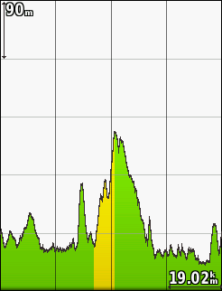
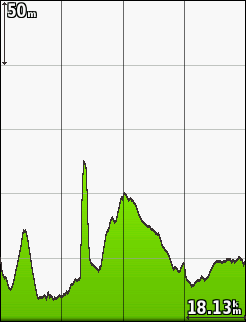
When it rains, the Edge barometer is often blocked by water, so that the elevation is not measured correctly. See this example of a route elevation vs. elevation measured by the Edge:
Is there any possibility to advice the Edge to calculate / record the elevation based on map data instead of the barometer, if the rider wants that in rainy conditions? (I want to fix it during recording, so that correct elevation is transferred to Strava. Elevation Correction of the Connect Website doesn't help.)
Best solution would be if the Edge detects automatically if the barometer-elevation doesn't fit to the map data elevation and suggests a correction based on map data in such case...


