This discussion has been locked.
You can no longer post new replies to this discussion. If you have a question you can start a new discussion

Long distance (160 km) problem with course

Hi

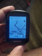
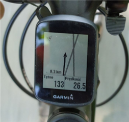
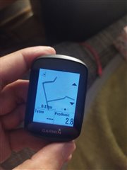
I made 160 km gpx file. I transfer file to New File in my Garmin 130 Plus (2.90). during my ride, I saw my course turn (50-70m) ealier- see picture. No all points was in course file. *.fit file

GPX file is OK

How you or I can fix this issue

  • If your course seems inaccurate, it's likely because the GPX track is inaccurate or not well-formed. I use the 130 a lot for navigation, designing my tracks in GPX format, and the process never failed me: the 130 does a very good job for such a small device.

    Not sure what tool/application you use to design your tracks (I use JOSM, it's powerful and gives you very fine control on each and every trackpoint, but it's not the most intuitive), but first thing I would try is to test the GPX on a website like GPX Studio, to make sure the track goes exactly where it is supposed to go.

    Second, I would pass your GPX through the Converter on GPS Visualizer, using this link which should already give you the right options. That would clean it up, add DEM elevation and generate a well-formed GPX file with a single track.

    Third, I would recommend to import the GPX into Garmin Connect, and from there send it to the 130, rather than putting it directly into the GARMIN\NewFiles folder. The web interface might be able to "digest" some imperfections in the GPX file, which the device itself might not.

  • How many points are in the file. The 130+ has a limited buffer size and will discard data points to keep the loaded file within the buffer size. This can result in some corners being cut a little as the path becomes simplified 

  • Good point. As a matter of fact, I always simplify the track in JOSM before loading it into Garmin Connect. For mountain biking, though, you don't want to simplify the track too much: first, you need the course to be precise as it helps navigating the trails, and second you want the trackpoints to be relatively close to each other (even on a straight line) otherwise the calculated Total Ascent will be far off.

    Do you have a ballpark number for the "buffer size" you mentioned? I just checked my longest course (GPX) and it has ~4500 trackpoints. The 130+ handled it beautifully.

  • Hi,

    gpx file was draw using http://brouter.de/brouter-web

    output:

    <?xml version="1.0" encoding="UTF-8"?>
    <!-- track-length = 166339 filtered ascend = 890 plain-ascend = 33 cost=256459 energy=.9kwh time=8h 52m 47s -->
    <gpx
    xmlns="">www.topografix.com/.../1"
    xmlns:xsi="">www.w3.org/.../XMLSchema-instance"
    xsi:schemaLocation="www.topografix.com/.../1 ">www.topografix.com/.../gpx.xsd"
    creator="BRouter-1.6.3" version="1.1">
    <trk>
    <name>brzesko</name>
    <trkseg>
    <trkpt lon="19.891661" lat="50.018401"><ele>225.75</ele></trkpt>

    3750 points

    <trkpt lon="20.608829" lat="49.985552"><ele>218.5</ele></trkpt>
    </trkseg>
    </trk>
    </gpx>

    File after gpsvisualizer.com looks the same

    <?xml version="1.0" encoding="utf-8" standalone="yes"?>
    <gpx version="1.1" creator="GPS Visualizer ">www.gpsvisualizer.com/" xmlns="">www.topografix.com/.../1" xmlns:xsi="">www.w3.org/.../XMLSchema-instance" xsi:schemaLocation="www.topografix.com/.../1 ">www.topografix.com/.../gpx.xsd">
    <trk>
      <name>brzesko</name>
      <trkseg>
        <trkpt lat="50.018401" lon="19.891661">
          <ele>225.751</ele>
        </trkpt>
    3750 points
        <trkpt lat="49.985552" lon="20.608829">
          <ele>220.036</ele>
        </trkpt>
      </trkseg>
    </trk>
    </gpx>

    once using garmin connect course 110km a saw also the same problem.
    next time i will use GC to long ride
    my previous garmin edge 200 has not this problem with course 550 km, 11200 trackpoints
  • If the file looks well-formed and it has only 3750 trackpoints (which is a number the 130 can certainly handle), then... are you sure the track was accurate in the first place? Check the specific point where you saw the track turning 50-70m earlier than actual... could you figure out if it was the track itself, or the 130? Maybe the issue lies with the website you used to trace your track...

  • this is route, gpx file transfer directly to device, its look the same like during the trip

    and route gpx file (the same like above, i find it in my PC) and it was import to Garmin and transfer via Garmin connect:

    WHY !? :-(

  • If you are 100% sure you started from the very same GPX, then I have to admit I'm surprised you ended up with such a noticeable difference. I think only Garmin would be in a position to explain this behavior, because it requires inner knowledge of how the device turns a GPX into a .FIT course, vs. what happens when you import a GPX in Connect.

    The only (obvious) advice I can give you is this: if loading a track via Garmin Connect gives you better results, stick to that!