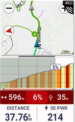
Is it possible on the 1050 to get the map to show on the climb pro screen also when a course is loaded or still only during free ride?
For me it is explainable:
-when Climb Pro starts with a loaded course (no map), you know: the climb must be part of your course.
-when Climb Pro starts without a loaded course (with map), you do not know where the climb leads to. It might be, that a climb starts at your current position, but is not part of your further track. So, you‘ll be informed at short hand.
Your explanation holds only if you use courses on the tracks you know, for training presumably, but when you use a map (and course) for navigation in a new terrain then you do not know when the climb leads to. Even worse, there can be a crossing just before or during the climb and the path choice might not be so obvious, in woods especially. BTW, that was my only reason to abandon climb pro at all.
There were a number of design changes to the ClimbPro page on the 1050.
The first is that it now uses a single page, so it is the same for free climb as well as when navigating.
The page has increased the font size used for the climb information
This data has also been reordered.
The page now supports either 2 or 4 data fields. Before it only support 2.
The section of the climb covered is now shaded on the elevation profile. The rider position is at the leading edge of the shading

There is new slider bar feature between the elevation section and map section. This allows you adjust the proportion of the screen given to the elevation and map sections.
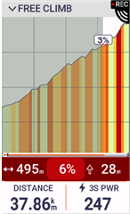
At the two extremes of the adjustment you can increase the elevation section to completely cover the map.
When in this mode the header will show FREE CLIMB when in free climb mode or will report the distance to the next climb when navigating.

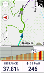
When maximizing the map area the elevation profile is shrunk down to the following.
