While the introduction of this feature promised to be interesting, its current implementation is nonsensical. Why I think so:
- the inability to set the radius-detection radius of notifications - driving on the completely opposite side of multi-lane roadways, I am informed of the approaching danger. A threat that is on the opposite side and does not affect my driving in any way (I have illustrated this in the screenshot)
- Lack of possibility to delete erroneously placed warnings - despite repeated denial of the occurrence of the threat, the alert still exists - this should be done by voting - the number of confirmations vs. denials, and I get the impression that placing the appropriate category of threat is guaranteed to be displayed “forever” ( e.g. pathole category )

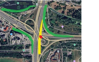
The first screenshot shows a situation where a placed danger point ( road works/surfacing - red spot/circle ) causes an alert to be displayed in a 250m radius. The only valid road for which it should display is marked in yellow, meanwhile the alert also displays when driving on routes marked in green.

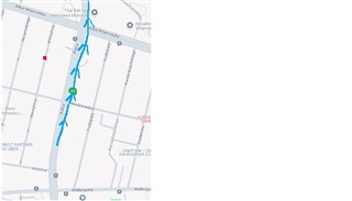
The second screenshot shows situations where a hazard (highlighted in red) is detected while driving along the route highlighted in blue at the point highlighted in green - the alert displays because, after all, I will cross the road, then through a house/village to find myself on a parallel road which, incidentally, does not take me where I am going. Garmin, really?
It all comes down to one option that is not there: setting the threat detection radius, because 250 meters is far too much for city driving conditions.


