Hi,
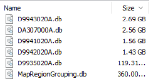
Got my new 1040 and there is only 0.5 GB available after updating maps! I've found that there are 8 GB of files in the SQL/Internal folder. Can't figure out what these are for. Can they be deleted?
Those contain the climb databases used to find climbs with the Climb Explore widget.
Do you need all maps for all the regions that are currently have installed? You can add/remove maps as needed.
If you use Garmin Express you can select manage maps and uninstall regions you don't need.
Hi aweatherall just out of interest, I'll do the damn thing to try... what happens if you delete the ClimbPro database files manually, will the CycleMap maps stop working either?
Thanks. Yes, I'd already managed the maps and even removed the African Topos but there was still not enough space to load the North American maps (I am on a trip from NZ to Europe then USA/Canada). That's when I ran a utility to see what was hogging the space and discovered 30% of the Garmin memory was used for these files in the SQL folder. If I delete them I have more than enough space for everything.
It contains all the information about all the climbs in the map coverage area that the climb explore can search/filter on
Min/Max difficulty
Terrain Type
Start location
There is also other information about climb systems and sections that are used when you are free riding to show branches off of the main climb.
If you remove these files you lose the ability to see climb branches when on a climb. You will still see the climb that the Edge has projected from the map data, not any alternative branches off of the projected path.