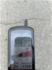
Such a cool feature if they can get it right (predictive climbs) but the graphics are just off. See attached for an example. It's consistently very different from the actual (the number gradient always seems pretty close)
Agreed - I find exactly this, too.
I've only been using my 1040 for just over a month, and have so far only ridden (very small!) local hills, but as it stands the graphic has been sufficiently inaccurate…
Last weekend I was climbing something around a 20% grade and it said I was going downhill lol.
I should say that when it's actually following a course I've loaded, it's MUCH better. But every single time it predicts a climb it will be very off.
Agreed - I find exactly this, too.
I've only been using my 1040 for just over a month, and have so far only ridden (very small!) local hills, but as it stands the graphic has been sufficiently inaccurate to make me think that Climb Pro is probably going to be fairly useless, really. I'll be trying it on some much longer and slightly less familiar climbs soon, and it will be interesting to see if I find it helpful.
Last weekend I was climbing something around a 20% grade and it said I was going downhill lol.
Tetherered vs. Free - tethered, it's using the supplied course data, whereas free it's using it's own database. The latter must be pretty vast, but it's clearly not all that accurate.
I suppose another question would be how well does Climb Pro work in Tethered mode when following a course generated in Connect, as opposed to one created from a previous ride (which will itself be subject to the accuracy of the device usind to record it, though I've found the 1040 to be very accurate in this respect, and certainly a significant improvement over the old 1000 it replaced, and a quantum leap from the 705s I used before that!).Whichever, it can only be as good as the data supplied, but I just wonder if the elevation data used for Connect is the same as the data held in the device's maps?
Yes - I've not had anything quite as dramatic as that (short on 20% climbs around here...), but I've had similar (and the reverse - descending whilst "climbing").
This was while following a course lol. I think something with the barometric reading may have been way off because it recorded a 1000’ climb as 200’ but still, it should be better than this.
I'm having the same issue, as well as out of sync climbs (before or after) where I could be going downhill and Climb pro thinks I'm climbing.