This discussion has been locked.
You can no longer post new replies to this discussion. If you have a question you can start a new discussion

17.09 beta update, climbPro and cycle map (full) Europe (the maps have all together 19,2 gb!)

I have downloaded the new 17.09 beta and followed the instructions for the installed cycle maps:

"Added support for viewing and riding ClimbPro climbs without navigating. Climbs will now be automatically detected when riding without a course or route. Additionally, with updated maps, climbs can be explored on the map or in the new Climb Explore widget and can be selected to be routed to and through. To get the maps, first update Edge software then update your region's Cycle Map via Garmin Express. If you already have the latest maps, uninstall and reinstall to download the ClimbPro maps."

After I had deleted the old cycle Europe maps from my 1040, I had 18,4 gb free memory on the device, but Express was telling me, that this is not enough free memory for the full cycle Europe map. Really? Ok, deleted another map with about 2,5 gb and the download started (20,9 gb free memory on my 1040).

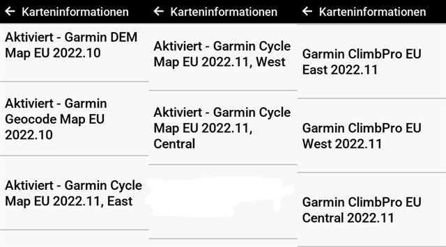
After the download, I looked at the size of the downloaded maps: full new cycle Europe maps (Garmin Geocode Map EU 2022.10; Garmin DEM Map EU 2022.10, Garmin cycle map EU 2022.11, East, Garmin cycle map EU 2022.11, West, Garmin cycle map EU 2022.11, Central) = 11,8 gb + 7,4 gb in the Garmin SQL folder on the device (seems to be the special climb maps for the new climbPro free riding feature; Garmin ClimbPro EU East 2022.11; Garmin ClimbPro EU West 2022.11, Garmin ClimbPro EU Central 2022.11 ) = 19,2 gb!!!

What about people with devices with only 16 gb memory (and the 16 gb are not full available)?

  • Those maps seem absolutely massive if all they contain is climbs. Wonder why that is. Certainly means you’d be crazy to buy a 540 with it’s limited memory. 

  • For devices with less space the user would need to install only the regions they need and not the whole of Europe if they wish to use ClimbPro with free climb detection.

    The new 540 that has 16 GB I think comes with 2 of the 3 EU regions pre-installed.

    Those totals are for the original EU maps plus the additional Climbing maps. The Climbing maps are installed in

    Garmin\SQL\Internal if you want to see how large they are.

  • Thanks, aweatherall. One question: if I delete the TA map/s and keep the climbing maps and use a free osm or a Garmin Topo Germany pro map, will the new free ride feature still work?

  • Fwiw that not enough memory message is a bug I think. I get it all the time despite having something like 40gb free

  • Think of the number of climbs on even a single route and you'd get an idea of why that is

  • To be honest > 90% of users don’t need that whole full Europe or not even regions maps (or Americas etc). It is really time that Garmin introduce a map system where the user is able to download only the counties they want/need, especially because the maps are getting bigger and bigger…

  • with 64gb of memory we don't have to worry about anything. i say they should fill each region with as much data (climb, profile, whatever) as possible and then as you said if there are those with lesser devices they can install whatever individual region they want

  • So the navigational maps and the ClimbPro maps are used at different times depending on what you are doing.

    You can think of the additional ClimbPro maps as a database of all climbs in a given area. Along with information about each climb such as length, ascent and average grade it also contains information on the climb terrain. (Paved, Unpaved, Mixed)

    When you are searching for a climb using the Climb Explore or browsing the map and dropping a pin on one of the red mountain icons that show a climb location on the map, then the Edge is using this database to find and report climbs.

    This database I image would be quite static, unless Garmin changes their search logic. The addition of new climbs in an area is likely to be quite small and would depend on new roads or trails be added. 

    When you are riding the Edge is dynamically profiling the path in front of you using the active navigational map and the DEM data to look and identify climbs. This is using the terrain data from the navigational map. 

    Will this work when using non-Garmin Cycling maps?

    The short answer is I don't know. If the map contains terrain data then it might, but you would be in an unsupported configuration if you did hit issues.

    Garmin has said that this feature works when using the cycling maps that they provide as part of the standard product. They have not made any statement about it working with other maps.

  • When you are riding the Edge is dynamically profiling the path in front of you using the active navigational map and the DEM data to look and identify climbs. This is using the terrain data from the navigational map. 

    Ah ok, thanks - I thought the device is taking the data (only) from DEM and the new climb map and the routable map source is not involved (my bad). But your explanation makes sense. I assume the cycle map, the DEM map and the climb map are coordinated to get good results. A very complex task that requires coordinated data. A different routable map might not offer that. But I think someone (not me) will try it with a different map and report about that, soon.

    aweatherall, are you going to update the great " Understanding ClimbPro on the Edge"  with free riding climb informations (I hope so!)?

    I have to come back to the ever-growing maps:

    Garmin should create a map system using Express, where the user can choose only the countries they want/need (or all devices should get a 64 gb memory). But as said before, almost no one needs really (for example) the full Europe map or even a Europe regions map (so the users spam up their memory with maps they never will need/use). Maybe you can pass my idea on to the Garmin cartography?

  • When you are searching for a climb using the Climb Explore or browsing the map and dropping a pin on one of the red mountain icons that show a climb location on the map, then the Edge is using this database to find and report climbs.

    Me again Grin I wasn't aware until now that there is a red mountain icon on the maps - I haven't seen it yet (or probably overlooked it). Wouldn't it make sense for the climbs to have their own POI category?